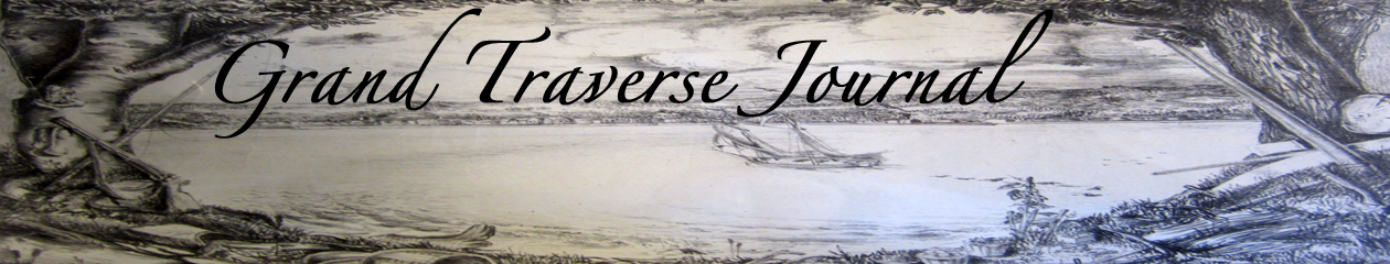
Just look at this beautiful brick street paver, a product of Metropolitan Block from well over 100 years ago! Like the Nelsonville Pavers, which we featured in a mystery photo way back in August 2015, this paver was, until recently, part of the roadway of Traverse City.
Here’s your question for July 2017: What two streets in TC are paved with brick?
Thanks to readers Cathy and Larry, we’ve got our answer! “Brick pavers are still visible on Sixth Street (Division to Union) and Eighth Street (Division to Union).”
Those streets may not be paved with gold, but they are paved with a whole lot of character!
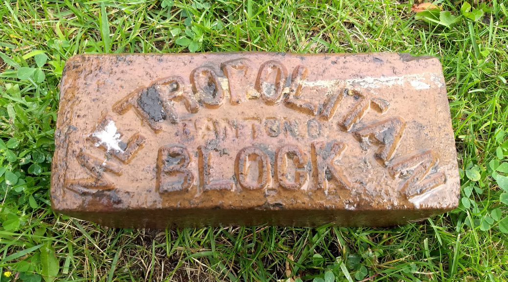
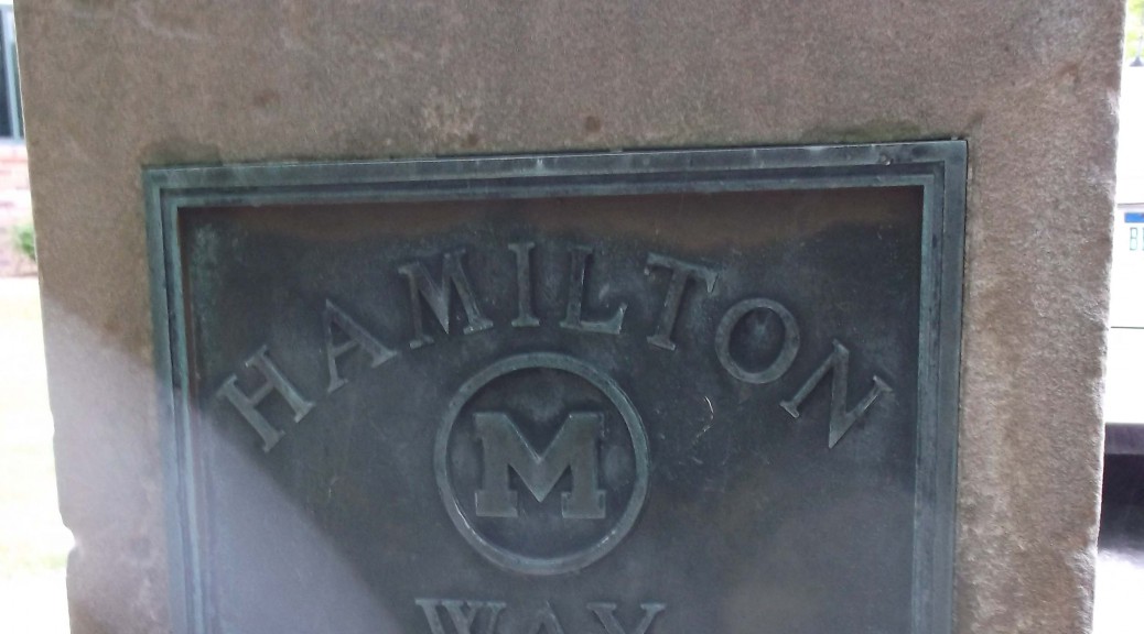
This monument located at Garfield Township Hall on Veterans Drive in Traverse City calls up a number of questions. Who was Hamilton? Why is his name associated with better roads? Why was it placed there? Any correct answers to the above questions will win you instant fame as a contributor to Grand Traverse Journal !
Thanks to Dr. Stacy Daniels, author of The Comedy of Crystal Lake, we have an answer for June’s Mystery Photo!:
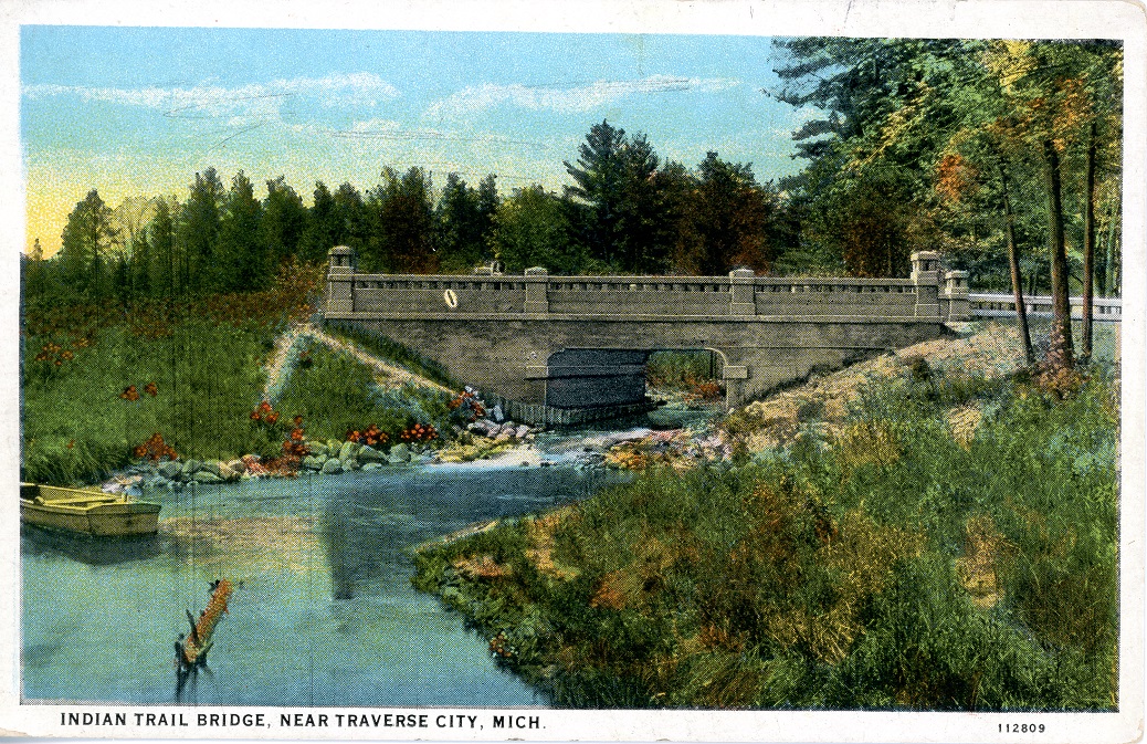
This colored postcard image depicts Indian Trail Bridge, which was actually Mitchell Creek bridge on the West Michigan Pike in Traverse City. This section was called ”Hamilton Way” after Frank Hamilton who was very dedicated to the development of roads in this area. The Indian Trail Camp Tourist hotel frequently had a sign up at this bridge, which may be why the creators called this image “Indian Trail Bridge”. Image courtesy of Tom Olds and Traverse Area District Library.
“Frank W. Hamilton (b 24 Nov 1848, Waterboro, York, Maine; d. 10 Sep 1940, Traverse City, Grand Traverse, MI) was Chairman of the Board of County Road Commissioners of Grand Traverse County so Hamilton Way was probably named after him. Curiously the story at Find-a-Grave.com doesn’t mention roads among his many accomplishments, including being a partner in Hamilton & Milliken. He appears to have been quite an esteemed citizen of TC – politician, businessman, bank director, and treasurer of the asylum.”
Good sleuthing, Stacy! Frank Hamilton was all the above, as well as being a leader in the “good roads” movement, which lead to the paving of many of the major thoroughfares in the region, especially the Circle Tour highway on the Leelanau Peninsula.
It’s 1910, and you’ve got the wagon hitched up, ready for a Sunday drive around Leelanau Peninsula… but there are no paved roads. Sometimes, you’re on a dusty, well- walked path, other times a bumpy two-track, and if you miss a turn, you’ll be in a farmer’s field. Bridges were scarce, and you might find yourself stuck on the wrong side of the river for miles. Not to mention, there are no shock absorbers on your old buckboard. Hamilton saw the value in creating a road system, to improve driving conditions for year-round citizens and visitors.
Dr. Daniels also found a number of digitized books that contain information, both on the “good roads” movement and Frank Hamilton himself. As you will read, his reach extended throughout all of Michigan, and wasn’t just limited to our neck of the woods. Here are a sample of those works for you to follow up on. As Dr. Daniels would say, “Happy Sauntering!”:
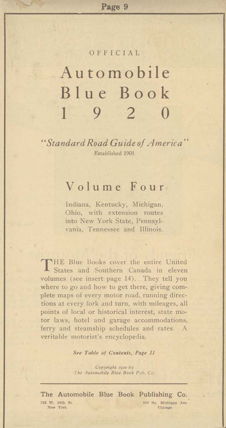
As a fumbling collector of automobile-related relics, I had long wondered why I couldn’t get road maps before the 1930’s. It took some time for me to understand that the folded maps offered free by the oil companies—Gulf, Shell, and Mobil—didn’t come out until the thirties. Before that time, I wondered, how did motorists navigate the highways in the first three decades of automobile travel?
My discovery of the Automobile Blue Book answered the question. Not to be confused with the Blue Book that gives the cash value of automobiles, the Automobile Blue Book was a navigational aid to motorists at the dawn of the automobile age. Through primitive maps and step-by-step written directions, it outlined routes from one destination to another, Traverse City to Benzonia, for example, or Traverse City to Old Mission.
Blue Books contained much more than directions about how to get from one place to another: They offered information about roads (dirt, gravel, crushed stone), steep grades, and blind curves, and recommended the best and safest routes to drivers and navigators. Along some roads they cautioned travelers about boulders and washed-out places. With the unreliable machines of the time, information about garages and hotels was included within the directions: A breakdown requiring repairs and an overnight stay could occur anywhere.
Successful auto trips required two partners—the driver and the navigator–since the driver cannot take time to keep looking at the book and the mileage while avoiding oncoming traffic, cattle blocking the highway, or ditches that loomed on either side of the road. An advertisement for a celluloid protector for the Blue Book showed a man in the driver’s seat with his spouse alongside, patiently (we would presume) giving instructions to her husband. Of course, women drivers were not unknown in the twenties either, and roles could be reversed.
At first, most cars lacked odometers altogether; they had to be purchased as an accessory. A starting point from each city center was designated—in Traverse City the junction of Union Street and Front served for all routes. Mileage was zeroed out at that point, all subsequent turns and landmarks measured in tenths of a mile. Like a modern GPS system, the navigator informed the driver of the route ahead, turns and distances, presumably in a calm voice that did not betoken a lack of confidence in the driver.
The Blue Book educated travelers about the areas to be explored. Of Old Mission Peninsula it generously wrote:
Grand Traverse peninsula [sic] extends 18 miles into Grand Traverse bay and varies from one to three miles in width and in height from bay level to several hundred feet. With its rugged shore line, many promontories, sandy beaches and sheltered bays, it is the most beautiful region in southern Michigan.
One can imagine travelers from remote places reading the Blue Book to educate themselves about the places they passed through. It was far more than a navigational aid: it was a book full of answers, much as our internet toys are now.
Upon receiving my Blue Book via an internet sale, I resolved to set out on a journey to catch the flavor of auto travel in the 1920s. Of course, it wouldn’t be the same: my Honda with its climate control system, stereo radio, comfortable seats, and relatively noiseless and dust-free operation would not capture the same sense of adventure (which, no doubt, was associated with the likelihood of misadventure) that motorists felt so long ago. I would not have to stop to fix flats as auto travelers frequently did in that era, in part because horseshoe nails no longer littered the roads. Highways and byways would be paved and smooth without the hazards of poor design, hasty construction, and the absence of highway warning signs (which hadn’t been standardized yet). In case of an accident I count on four air bags deploying at once while a Model T lacked seat belts and the advantage of a cabin protected by a cocoon of metal that can withstand crashes at 40 miles per hour. Perhaps all of that safety gear was not necessary given that the speed limit in Michigan and practically anywhere else in the country was slower than a horse’s gallop, 25 miles per hour.
One of my Backspacer friends (the Backspacers are a tiny group of persons interested in local history), Marly Hanson, agreed to act as navigator during our journey. Possessing the preciseness of mind and the devotion to detail of a former reference librarian at the Traverse Area District Library, she was well suited for the job. While we were never in danger of getting lost, we would often have to make sense out of outdated instructions. After some consideration, we decided to go to Leland by way of Suttons Bay and Lake Leelanau, a short jaunt that could be done in a couple of hours or so. And so, with Blue Book in hand one early September day, we set out on our adventure.
We zeroed out the odometer at the corner of Front and Union in front of the 5/3 bank, already feeling a sense of connectedness to our history since a bank had stood there in 1920, the Traverse City State Bank, founded by Perry Hannah, one of the founders of our town. However, we quickly realized that the Grandview Parkway did not exist at that time, an extended Bay Street carrying the traffic towards Leelanau county. Still, odometer readings were in fairly good agreement with the book as we crossed imaginary railroad tracks—now the TART trail—as we passed 72 which led up the long hill to the west of town.
At 2.6 miles we were told to turn left, onto what is now Cherry Bend road, and this we did. A church was at the corner as indeed it was the West Bay Covenant Church. We expected to turn away from the bay here since the road from Traverse City did not proceed directly to Suttons Bay as it does now. It went inland and rode the ridge high up from the water.
At approximately 9.7 miles we passed through a 4-corners with school and church—now Bingham–those buildings having been converted to the township hall and to a residence respectively. It was a straight sail to the end of the road and a large brick church, St. Michaels, in Suttons Bay. The trip had been easy so far, the roads no longer gravel but paved and straight for the most part. Old maples lined the highway, still standing after having been planted by local farmers ninety or more years ago. They were showing signs of age, premature aging, perhaps, due to the salt applied in winter.
Pages 931 and 932 of the Blue Book, detailing trip author took.
The entrance to Suttons Bay was different from now, the old road joining up with the modern one before the fire station which still stands, though now converted to a restaurant. Resisting an urge to spend time in the village, we proceeded out of town, up a “long, winding grade”—surely a staggering job for the engine of a Model T laboring to bring the car through gravel on a hot summer’s day. Reaching the top, we settled down for the long descending trek towards Lake Leelanau, that name being “Provemont” in 1920.
Before we crossed the channel, we read a cryptic note: “4-corners; turn diagonally left. Cross channel connecting Lake Leelanau 4.3” The 4-corners still remains, but there is no possibility of a diagonal left turn: the bridge extends straight-ahead. Leaving town, we see that Main Street crosses our highway: Could it be that the bridge had been moved to the north, separating “Main Street” from the passage across the narrows? We would learn more on our return.
Leland at last! We turned right, away from the waterfront to the center of the village, presumably a plot of land where the courthouse stood. Fairly recently that institution has been moved outside the village to a location along the road we had just traveled. Forlorn as if awaiting its possible demise, an old brick building with barred windows stood in a mowed field–the county jail–a vestige of the rule of law in this place. The center of town has moved from here to the busy commercial strip along M-22 and in Fishtown.
Marly and I stopped to get lunch and serendipitously met a friend, David Grath, who had information that would help us understand the mysterious directions given us in Lake Leelanau. Attracted to this area as a youth, David has explored the northern parts of Leelanau county since 1957, using his geographical knowledge to build an international reputation as a landscape painter. Keenly interested in local history as well, he tells us the bridge has been moved some time ago to the north. “If you go down by Lake Leelanau St. Mary’s cemetery to the dock extending into the narrows and look down, you can see the concrete slabs that made up the foundation of the old bridge. Main Street, used to be the main drag through town, only after they built the new bridge, it became a side street.”
We got in the car and returned to Lake Leelanau, eager to see if evidence of the old bridge can still be found. We passed the school and wound down a moderately steep hill to a dock that extended into the narrows. Walking out on it and looking down into the water, we saw slabs of concrete, surely relics of the 1920 crossing. The road on the other side would have had to bend diagonally to meet the bridge as the directions declared. Upon reaching the west bank, Main Street would have carried traffic through the tiny town: only a store and post office were mentioned as landmarks to look for. The post office is now gone, having been moved across the highway to St. Joseph Street, though a small frame building looking old enough to serve as “the store” remains. Provemont—Lake Leelanau—was not a major stop for travelers in 1920 or in 2014.
So it was that we completed our day of travel following directions given in our Blue Book. Without need of wiping the dust from our faces or the perspiration from our brows, we returned to Traverse City the direct way, along the Bay. Our journey was without the romance of early automobile travel, but still provided the smallest glimpse into how motoring used to be. We decided we would plan another Blue Book guided trek to a new destination in coming weeks. Who knows what relics of history will be illuminated in that adventure?
Note: Readers may visit the Woodmere branch of the library to inspect this Blue Book in the Nelson Room. Pages may be photocopied for those wishing to plan an expedition using Blue Book instructions. Happy motoring!
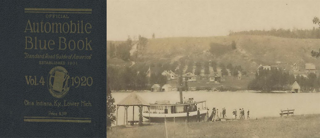
Richard Fidler is co-editor of Grand Traverse Journal. The image within the header is of Provemont, the “ghost town” of Lake Leelanau, and the steamer SS Leelanau, ca. 1908; Image courtesy of Don Harrison, Up North Memories, https://flic.kr/p/s6YaBg
Locally-produced digital magazine featuring nature and local history from the Grand Traverse Region.