With this very issue the Grand Traverse Journal marks its one-year anniversary. Like proud parents, the editors have watched the accomplishments of the foundling with much pride. It charmed us with Bill Scharf’s description of gulls on Gull Island; it confronted us with the truth about the so-called ghost of Bowers Harbor in Julie Schopieray’s October piece; it informed us how a frame church could be moved through the streets of Traverse City in the eighteen nineties thanks to Amy Barrit’s explanation in the November issue; it acquainted us with a new friend in Mud Turtle Jack, Valerie Himick’s remembrance of her grandfather. Thanks to the Journal, readers know about The Great Meteor of 1879, the history of local railroads, the first bus line in Traverse City, and the experiences of nurses, farmers, and veterans of World War II.
Our Grand Traverse Journal has uncovered relics from the past: an old recipe book, a 1919 editorial decrying the abuses of the “5 percent,” an account of a midnight ride through the Peninsula in the nineteenth century, a poem written in 1890 that touches us with its description of Grand Traverse Bay in the language of the time.
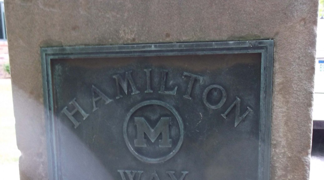
The Journal has exposed its readership to images of history all around us: images of an art-deco granite eagle on the Union Street post office, the profile of an Indian on a pump house on Front Street, the stretch of sidewalk at Clinch Park that honors the Anishnaabek presence in the Grand Traverse Area, a road marker emblazoned with the words Hamilton Way found at the Garfield Township hall just outside the city limits.
We cannot count all of the articles writers have submitted, the feedback readers have submitted, the comments—all approving—we have heard regarding our one-year-old magazine.In response we wish to thank our supporters–in particular, all of the writers and readers who offered their time to make us a success.With your continued help, we look forward to another year of growth.
This monument located at Garfield Township Hall on Veterans Drive in Traverse City calls up a number of questions. Who was Hamilton? Why is his name associated with better roads? Why was it placed there? Any correct answers to the above questions will win you instant fame as a contributor to Grand Traverse Journal !
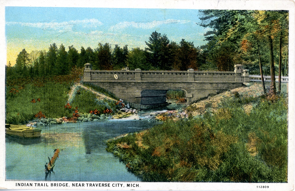
Thanks to Dr. Stacy Daniels, author of The Comedy of Crystal Lake, we have an answer for June’s Mystery Photo!:
This colored postcard image depicts Indian Trail Bridge, which was actually Mitchell Creek bridge on the West Michigan Pike in Traverse City. This section was called ”Hamilton Way” after Frank Hamilton who was very dedicated to the development of roads in this area. The Indian Trail Camp Tourist hotel frequently had a sign up at this bridge, which may be why the creators called this image “Indian Trail Bridge”. Image courtesy of Tom Olds and Traverse Area District Library.
“Frank W. Hamilton (b 24 Nov 1848, Waterboro, York, Maine; d. 10 Sep 1940, Traverse City, Grand Traverse, MI) was Chairman of the Board of County Road Commissioners of Grand Traverse County so Hamilton Way was probably named after him. Curiously the story at Find-a-Grave.com doesn’t mention roads among his many accomplishments, including being a partner in Hamilton & Milliken. He appears to have been quite an esteemed citizen of TC – politician, businessman, bank director, and treasurer of the asylum.”
Good sleuthing, Stacy! Frank Hamilton was all the above, as well as being a leader in the “good roads” movement, which lead to the paving of many of the major thoroughfares in the region, especially the Circle Tour highway on the Leelanau Peninsula.
It’s 1910, and you’ve got the wagon hitched up, ready for a Sunday drive around Leelanau Peninsula… but there are no paved roads. Sometimes, you’re on a dusty, well- walked path, other times a bumpy two-track, and if you miss a turn, you’ll be in a farmer’s field. Bridges were scarce, and you might find yourself stuck on the wrong side of the river for miles. Not to mention, there are no shock absorbers on your old buckboard. Hamilton saw the value in creating a road system, to improve driving conditions for year-round citizens and visitors.
Dr. Daniels also found a number of digitized books that contain information, both on the “good roads” movement and Frank Hamilton himself. As you will read, his reach extended throughout all of Michigan, and wasn’t just limited to our neck of the woods. Here are a sample of those works for you to follow up on. As Dr. Daniels would say, “Happy Sauntering!”:
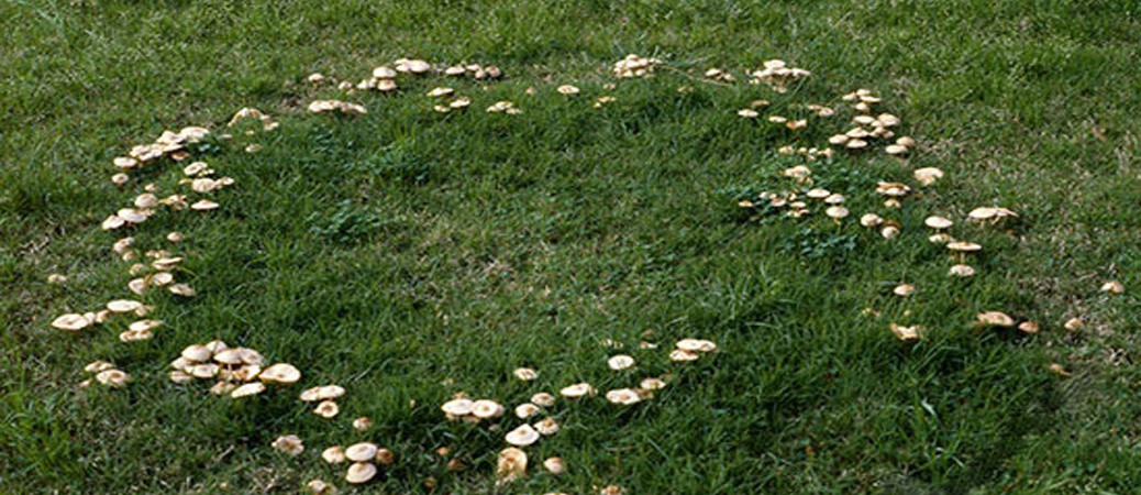
Fairy rings- circles of mushrooms growing in yards are known—and sometimes respected- by both children and grown-ups.“Respected” because, according to Irish and Welsh legend, they are places inhabited by the wee folk, fairies and leprechauns.Within the circles they dance, sometimes enticing a human passer-by to join them, much to his eventual regret. Once inside the ring, he cannot get out and is compelled to dance until exhaustion and death carry him away.Fairy rings deserve respect: it is at your own peril if you enter them.
Image of Fairy Ring, composed of Marasmius oreades. Image courtesy of Steve Trudell.
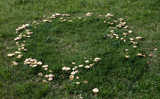
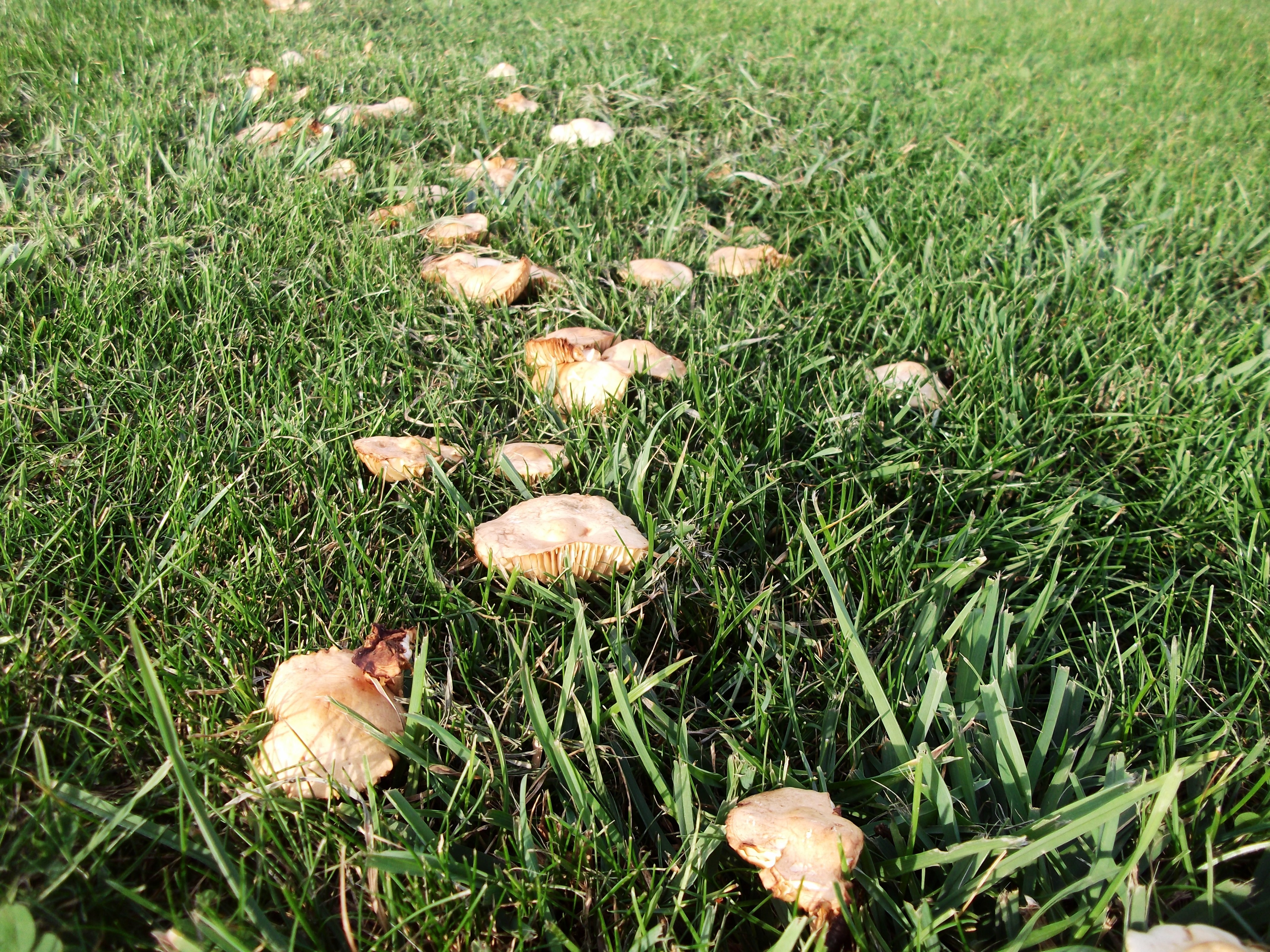
Many kinds of mushrooms form fairy rings, but the commonest is probably Marasmius oreades, the fairy ring mushroom.It has an off-white cap with widely spaced gills, a slender fibrous stalk without a ring, and white spores.Unlike most mushrooms which decay and rot over time, Marasmius mummifies in summer heat, shrinking to a fraction of its fresh size, its firm flesh becoming tough and leathery over time.
If a fresh rain falls upon the mushroom, it perks up, expanding to its former size and regaining its firm texture.Not only does it appear to resurrect itself, it actually does that very thing.It has been shown that Marasmius oreades resumes its life processes, respiring and consuming food, even producing new spores on its gills.Somehow it goes into suspended animation for as long as a summer drought holds on, only to continue its business when growing conditions improve.
One hypothesis explaining the resurrection is the presence of a special sugar within the flesh of the mushroom, trehalose.After a dry spell, rainwater is absorbed, thereby dissolving the sugar–which enters cells, reviving and stimulating them to divide.This Marasmius is considered edible (but not especially delicious), having been incorporated into recipes for omelets, gravies, and even chocolate chip cookies.Perhaps the trehalose sugar helps the cookies taste better, though I suspect that the best change to the recipe would be to leave the mushrooms out.
The Fairy Ring Mushroom, Marasmius oreades. Image courtesy of Les Chatfield.
Marasmius oreades grows in circles for a very good reason.It starts out when a mushroom spore lands in a favorable place for food, decayed matter underground.It spreads out a net of slender cells, hyphae (collectively called the mycelium), eventually reaching a size large enough to send up its first fruiting bodies, the familiar mushrooms we see above ground.Year by year the mycelium grows outward, forever producing new crops of mushrooms at its outer margin.The circle gets bigger, five feet in diameter, then ten, then even larger—certainly big enough to accommodate a large band of dancing fairies and an occasional hapless human.
Within the circle the grass may appear yellow and exhausted: the mushroom has absorbed nutrients in the soil, while at the edge it may be green and luxuriant as nutrients are released to be absorbed by the fungus and neighboring grass plants. Overzealous yard managers sometimes try to get rid of the circles of mushrooms, preferring the monotony of turf to the disorderliness of fairy ring mushrooms.They are seldom successful.
To end this piece one can do no better than to quote a poem about fairy rings, this one unsigned:
If you see a fairy ring In a field of grass, Very lightly step around, Tiptoe as you pass; Last night fairies frolicked there, And they’re sleeping somewhere near.
If you see a tiny fay Lying fast asleep, Shut your eyes and run away, Do not stay or peep; And be sure you never tell, Or you’ll break the fairy spell.
Richard Fidler is co-editor of Grand Traverse Journal.
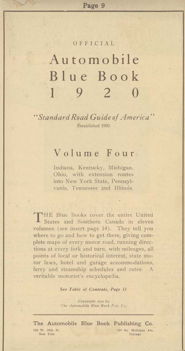
As a fumbling collector of automobile-related relics, I had long wondered why I couldn’t get road maps before the 1930’s. It took some time for me to understand that the folded maps offered free by the oil companies—Gulf, Shell, and Mobil—didn’t come out until the thirties. Before that time, I wondered, how did motorists navigate the highways in the first three decades of automobile travel?
My discovery of the Automobile Blue Book answered the question. Not to be confused with the Blue Book that gives the cash value of automobiles, the Automobile Blue Book was a navigational aid to motorists at the dawn of the automobile age. Through primitive maps and step-by-step written directions, it outlined routes from one destination to another, Traverse City to Benzonia, for example, or Traverse City to Old Mission.
Blue Books contained much more than directions about how to get from one place to another: They offered information about roads (dirt, gravel, crushed stone), steep grades, and blind curves, and recommended the best and safest routes to drivers and navigators. Along some roads they cautioned travelers about boulders and washed-out places. With the unreliable machines of the time, information about garages and hotels was included within the directions: A breakdown requiring repairs and an overnight stay could occur anywhere.
Successful auto trips required two partners—the driver and the navigator–since the driver cannot take time to keep looking at the book and the mileage while avoiding oncoming traffic, cattle blocking the highway, or ditches that loomed on either side of the road. An advertisement for a celluloid protector for the Blue Book showed a man in the driver’s seat with his spouse alongside, patiently (we would presume) giving instructions to her husband. Of course, women drivers were not unknown in the twenties either, and roles could be reversed.
At first, most cars lacked odometers altogether; they had to be purchased as an accessory. A starting point from each city center was designated—in Traverse City the junction of Union Street and Front served for all routes. Mileage was zeroed out at that point, all subsequent turns and landmarks measured in tenths of a mile. Like a modern GPS system, the navigator informed the driver of the route ahead, turns and distances, presumably in a calm voice that did not betoken a lack of confidence in the driver.
The Blue Book educated travelers about the areas to be explored. Of Old Mission Peninsula it generously wrote:
Grand Traverse peninsula [sic] extends 18 miles into Grand Traverse bay and varies from one to three miles in width and in height from bay level to several hundred feet. With its rugged shore line, many promontories, sandy beaches and sheltered bays, it is the most beautiful region in southern Michigan.
One can imagine travelers from remote places reading the Blue Book to educate themselves about the places they passed through. It was far more than a navigational aid: it was a book full of answers, much as our internet toys are now.
Upon receiving my Blue Book via an internet sale, I resolved to set out on a journey to catch the flavor of auto travel in the 1920s. Of course, it wouldn’t be the same: my Honda with its climate control system, stereo radio, comfortable seats, and relatively noiseless and dust-free operation would not capture the same sense of adventure (which, no doubt, was associated with the likelihood of misadventure) that motorists felt so long ago. I would not have to stop to fix flats as auto travelers frequently did in that era, in part because horseshoe nails no longer littered the roads. Highways and byways would be paved and smooth without the hazards of poor design, hasty construction, and the absence of highway warning signs (which hadn’t been standardized yet). In case of an accident I count on four air bags deploying at once while a Model T lacked seat belts and the advantage of a cabin protected by a cocoon of metal that can withstand crashes at 40 miles per hour. Perhaps all of that safety gear was not necessary given that the speed limit in Michigan and practically anywhere else in the country was slower than a horse’s gallop, 25 miles per hour.
One of my Backspacer friends (the Backspacers are a tiny group of persons interested in local history), Marly Hanson, agreed to act as navigator during our journey. Possessing the preciseness of mind and the devotion to detail of a former reference librarian at the Traverse Area District Library, she was well suited for the job. While we were never in danger of getting lost, we would often have to make sense out of outdated instructions. After some consideration, we decided to go to Leland by way of Suttons Bay and Lake Leelanau, a short jaunt that could be done in a couple of hours or so. And so, with Blue Book in hand one early September day, we set out on our adventure.
We zeroed out the odometer at the corner of Front and Union in front of the 5/3 bank, already feeling a sense of connectedness to our history since a bank had stood there in 1920, the Traverse City State Bank, founded by Perry Hannah, one of the founders of our town. However, we quickly realized that the Grandview Parkway did not exist at that time, an extended Bay Street carrying the traffic towards Leelanau county. Still, odometer readings were in fairly good agreement with the book as we crossed imaginary railroad tracks—now the TART trail—as we passed 72 which led up the long hill to the west of town.
At 2.6 miles we were told to turn left, onto what is now Cherry Bend road, and this we did. A church was at the corner as indeed it was the West Bay Covenant Church. We expected to turn away from the bay here since the road from Traverse City did not proceed directly to Suttons Bay as it does now. It went inland and rode the ridge high up from the water.
At approximately 9.7 miles we passed through a 4-corners with school and church—now Bingham–those buildings having been converted to the township hall and to a residence respectively. It was a straight sail to the end of the road and a large brick church, St. Michaels, in Suttons Bay. The trip had been easy so far, the roads no longer gravel but paved and straight for the most part. Old maples lined the highway, still standing after having been planted by local farmers ninety or more years ago. They were showing signs of age, premature aging, perhaps, due to the salt applied in winter.
Pages 931 and 932 of the Blue Book, detailing trip author took.
The entrance to Suttons Bay was different from now, the old road joining up with the modern one before the fire station which still stands, though now converted to a restaurant. Resisting an urge to spend time in the village, we proceeded out of town, up a “long, winding grade”—surely a staggering job for the engine of a Model T laboring to bring the car through gravel on a hot summer’s day. Reaching the top, we settled down for the long descending trek towards Lake Leelanau, that name being “Provemont” in 1920.
Before we crossed the channel, we read a cryptic note: “4-corners; turn diagonally left. Cross channel connecting Lake Leelanau 4.3” The 4-corners still remains, but there is no possibility of a diagonal left turn: the bridge extends straight-ahead. Leaving town, we see that Main Street crosses our highway: Could it be that the bridge had been moved to the north, separating “Main Street” from the passage across the narrows? We would learn more on our return.
Leland at last! We turned right, away from the waterfront to the center of the village, presumably a plot of land where the courthouse stood. Fairly recently that institution has been moved outside the village to a location along the road we had just traveled. Forlorn as if awaiting its possible demise, an old brick building with barred windows stood in a mowed field–the county jail–a vestige of the rule of law in this place. The center of town has moved from here to the busy commercial strip along M-22 and in Fishtown.
Marly and I stopped to get lunch and serendipitously met a friend, David Grath, who had information that would help us understand the mysterious directions given us in Lake Leelanau. Attracted to this area as a youth, David has explored the northern parts of Leelanau county since 1957, using his geographical knowledge to build an international reputation as a landscape painter. Keenly interested in local history as well, he tells us the bridge has been moved some time ago to the north. “If you go down by Lake Leelanau St. Mary’s cemetery to the dock extending into the narrows and look down, you can see the concrete slabs that made up the foundation of the old bridge. Main Street, used to be the main drag through town, only after they built the new bridge, it became a side street.”
We got in the car and returned to Lake Leelanau, eager to see if evidence of the old bridge can still be found. We passed the school and wound down a moderately steep hill to a dock that extended into the narrows. Walking out on it and looking down into the water, we saw slabs of concrete, surely relics of the 1920 crossing. The road on the other side would have had to bend diagonally to meet the bridge as the directions declared. Upon reaching the west bank, Main Street would have carried traffic through the tiny town: only a store and post office were mentioned as landmarks to look for. The post office is now gone, having been moved across the highway to St. Joseph Street, though a small frame building looking old enough to serve as “the store” remains. Provemont—Lake Leelanau—was not a major stop for travelers in 1920 or in 2014.
So it was that we completed our day of travel following directions given in our Blue Book. Without need of wiping the dust from our faces or the perspiration from our brows, we returned to Traverse City the direct way, along the Bay. Our journey was without the romance of early automobile travel, but still provided the smallest glimpse into how motoring used to be. We decided we would plan another Blue Book guided trek to a new destination in coming weeks. Who knows what relics of history will be illuminated in that adventure?
Note: Readers may visit the Woodmere branch of the library to inspect this Blue Book in the Nelson Room. Pages may be photocopied for those wishing to plan an expedition using Blue Book instructions. Happy motoring!
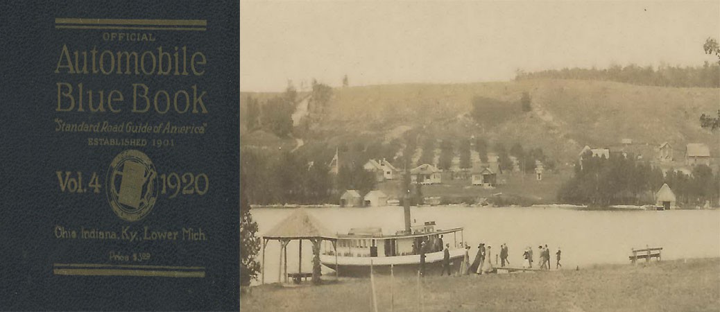
Richard Fidler is co-editor of Grand Traverse Journal. The image within the header is of Provemont, the “ghost town” of Lake Leelanau, and the steamer SS Leelanau, ca. 1908; Image courtesy of Don Harrison, Up North Memories, https://flic.kr/p/s6YaBg
(This article continues a series. Please see the third and second place winners in previous issues of Grand Traverse Journal).
By Genevieve Pomerleau (center), First Place winner in the 2015 Bruce Catton Awards
Go into Frankfort, Michigan, turn west on Forest Avenue, then make a right onto Michigan Avenue, and keep going north until you reach Nipissing Street. Once you’re there, make a left and go to the end. Look to your left, and you’ll find a set of small, mossy stairs that lead to the beach. Go down the steps and walk alongside the water for a short ways north. Eventually, you will come across a small stream coming down from the sloped ground on your right.
In the summer of 2008, when I was seven years old, my brother, our friends, and I spent most of our time at Frankfort’s Lake Michigan beach there, at the stream. We would use the mud to make dams in the stream, then break them up and try to get the water to flow all the way to the lake, and we would climb up into the woods and make forts out of old logs and fallen tree branches.
One day, my friend, Ted (who was ten-years-old at the time) suggested that we climb up the hill- following the water- to see where the stream originated. We positioned ourselves on the right side of the small creek and started up the crumbling clay to the next flat area we knew of.In hindsight, we probably should have climbed on the left side so that there would have been more trees and bushes to hold onto for support. It wasn’t a very far distance, but when you’re a small child, everything seems a lot larger.
When we reached the miniature plateau, we spent a few minutes trying to get onto the flat ground. A large branch that had fallen a long time ago had caused a buildup of dirt and clay that formed a small cliff. Ted climbed up the branch and clawed onto the top; then held out his hand and pulled me up. We stopped for a moment and watched the stream flow beside us through the little canyon it had created. Across it, there was more flat ground. It was as though someone had taken a giant knife and carved a huge step into the side of the steep hill.We built most of our forts there. Right below it, the stream split into two; one going down to the area where we spent most of our time; the other smaller one going deeper north into the woods. We then stepped into it and continued upstream that way. We could hang onto tree roots coming out of the sides of the little valley, making our expedition easier.
Eventually, we reached the end (or should I say the beginning?) and found that the start of the creek was a large mud puddle. It was a gray/cream color, but clearish water flowed out of it and down the hill. We knelt down and picked up some of it with our hands. It was squishy, and felt like wet clay. I took a step toward it; then I put a foot on the soft surface. It felt hard enough, so I lifted up my other leg. Immediately, my right foot squelched through the seemingly solid ground and pulled me in with it. Just before the mud and clay completely covered my head, my toes touched the bottom. I wriggled through the murk until I reached the side and Ted pulled me out. We spent a little while playing around with the sludge, jumping in on purpose and almost swimming in the ooze. Eventually we stopped and took a break on dry ground. We both looked like some sort of mud monsters.
Ted suggested that we should keep climbing to see what was at the very top. I agreed, and we began working our way through the thick bushes and trees. After a while, the vegetation broke and we reached a wooden split rail fence. Beyond it was a well- kept yard with a large stone house resting upon it. We hopped over the fence and onto the grass. The sound of a door opening made us both jump. Ted whispered for me to run, and before I knew it we were over the fence and racing down the perilous incline. We sprinted past the mud-hole without stopping and crashed through the woods as if a bull were chasing us. When we came to the flat area, we just kept going, leaping off the cliff without thinking. It seemed a full ten seconds before we hit the ground and continued running. Gasping for air, we splashed through the stream, darted across the beach, and finally dove into the water.
We stayed there, floating in the lake, for what might have been a half-hour. We caught our breath, letting the sun warm our faces, watching the dried clay on our bodies become wet and float off into the water.
Congratulations to Genevieve Pomerleau for her excellent essay, and her first place finish! We look forward to reading more from Genevieve.
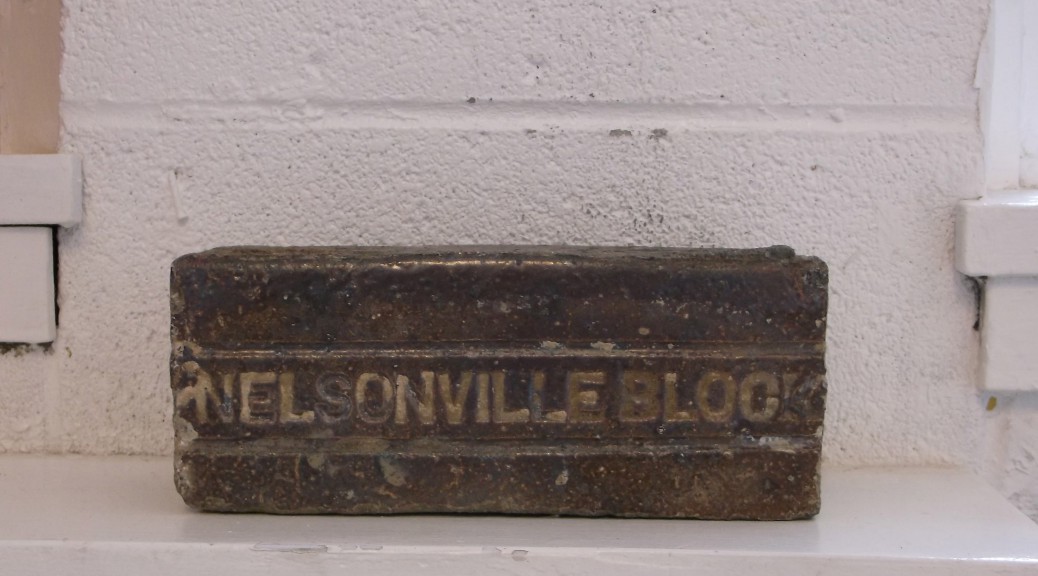
Never thought about the paving that covered Front Street west of Union in the first years of the 20th century?Neither did the workers who unearthed antique paving bricks (“pavers”).By surprise, they discovered a whole roadbed of them, each one of which will have to be removed before resurfacing begins.Perhaps, we are told, they will be reused in building projects around the area.
Who, among our readers, knows something about the Nelsonville, Ohio, brickworks that produced the specimens photographed here?How are “pavers” different from building bricks?All you stone masons, lovers of antique bricks, and internet junkies go to work and educate us!
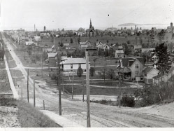
In April 2015, Dr. Elms’ house was torn down. In this photograph, ca. 1890s, the home is closest to the camera, set back from Union Street (far right).
by Julie Schopieray
The recent demolition ofa once lovely, large house on S. Union Street, kindled the desire to investigate the history of the home. Built before 1888, it was firstthe home of GeorgeE. Steele andlocated in the south side subdivision known as Fernwood.
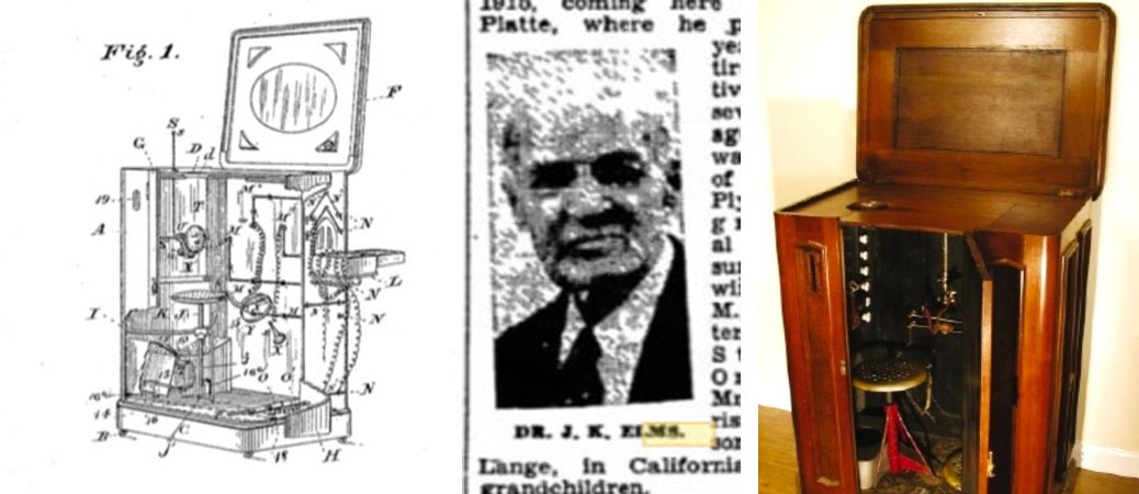
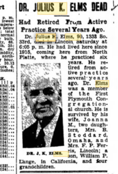
In 1888, Steele sold it to real estate dealer Philip Lang. After Lang’ssudden death in 1890 (he shot himself in the basement of the home),his widow Anna marriedDr. Julius K. Elms, a homeopathist and surgeon, who came to Traverse City in 1881 and practiced medicine in various villages in the Grand Traverse area. By the mid-1890s, Dr. Elms had a well established practice with an office on the upper floor of the Markham block at 129 E. Front St. A capable physician trained in Chicago, he successfully tended to the needs of the community, but, by 1898, was struggling to make ends meet, having made a risky investment which may have doomed his career in Traverse City.
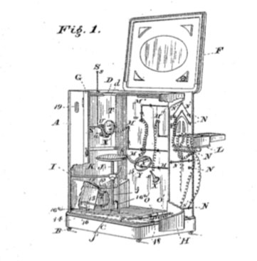
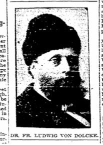
OnFebruary8, 1898,Dr. Ludwig Von Dolcke and his female assistant, Miss Hattie V. Hadley,arrived at the Park Place hotel.The doctor immediately began to run ads in the local paper, obviously written by himself, carefully worded to lure curious and desperatepatients to try his treatments.“Dr. Ludwig von Dolcke, the eminent inventor of the electro-theropeutic cabinet bath, and who is termed “nature’s doctor,” is …in the city and he will be pleased to give free consultation to a limited number during the remainder of his stay at the Park Place which will not be long….” Von Dolcke had patented his version of an electric bath cabinet in 1884.
These devices were first invented in the mid-1870s, so Von Dolcke was not the first to patent one- hiswas an “improved version.”It was basically a large lidded wooden box with a stool and wiring connected to“electrode sponges” which were placed on the part of the body to be treated. Powered by a battery, a patient could be given various levels of electric current from mild, to as strong as desired. Holes in the cabinet allowed for employing vapor ( Russian bath)or hot air (Turkish bath) depending on the type of bath requested. The treatments were said to increase circulation, help symptoms of Brights Disease, rheumatism, dropsy, eczema and other skin affections, gout and many other maladies.
Dr. Von Dolcke’s presence in Traverse City seems to have stirred some suspicion, however. Local physician Dr. H.B. Garner had likely heard of his reputation, and questioned whether Von Dolcke had registeredto practice medicine during his electric bath sessions in town.Von Dolcke was charged five dollars for violating the state law, and did register a couple weeks after arriving, claiming ignorance about having to register to practice medicine in the county.
For nearly fifteen years Von Dolcke had traveled the Midwest selling his inventions to small town doctors.A flamboyant character often seen wearing odd costumes, his credentials were sketchy at best–one article stated his medical training was earned at the University of Iceland, and another said it was in Sweden.After inventing his first electric therapy bath in 1884, he opened the Electro-Hygenic Institute in Cincinnati where he trained people (usually women) to use the devices, sending them out to sell them across the country.
He had gained a reputation across the country for making wild medical claims. He charged outrageous amounts for his electric bath cabinets, and was sued numerous times for various reasons–including practicing medicine without a license, refusing to testify in court about the death of a young woman after a botched abortion, and in 1891, inventing a scheme (which was widely covered in papers across the country) to move the entire population of Iceland (the place he proclaimed to be his homeland) to Alaska where he claimed to be working with capitalists.
Dr. Von Dolcke stated he’d traveled the world and even treated Queen Victoria and other European notables, bragging that he, himself, was a descendant of Danish nobility. In fact, no trace of the man’s heritage can be documented, nor his existence under that name before 1882.Unbelievably, in one interview he claimed he’d come to the country in 1844 as a “commissioner” to select the land in Dakota territory where a colony of 6,000 Icelanders would eventually settle. The problem with that claim is that he would have only been about two years old in 1844.His reputation was well known in Michigan since he had established practices in Grand Rapids and Detroit (and had been sued in both cities).It was no surprise that some people were wary of his intentions when he arrived in Traverse City.
The ads the Von Dolcke placed in the newspapers paper during his visit in 1898, made claims for all sorts of cures from his treatments, just as other “doctors” did with these machines since they first appeared about 1874. The most famous physician in Michigan during this time was Dr. John Kellogg of Battle Creek, whose successful sanitarium drew sufferers from all over the country. The notoriety of Kellogg, who also used a version of electric bath therapy, may have added to the surprising success of Dr. Von Dolcke’s invention. During their time in Traverse City, Von Dolcke’s female partner ran the treatments for women. Ads boasted of the success she was having with the ladies of Traverse City.
“Miss Hattie V. Hadley, came to this city a few weeks ago to introduce the bath which was entirely new to Traverse City people but it is already becoming widely known as those who first tried its health givingproperties were so pleased with its success, that the good word had passed along until now Miss Hadley had nearly every hour taken with ladies seeking relief from ailments which have become chronic.Among her patients are ladies who have already experienced marvelous changes in their physical being and they cannot commend the method enough.[Traverse City Evening Record Feb. 13, 1898]
Dr. Elms seems to have been completely taken in by Von Dolcke’s free demonstrationsand within a month, the paper announced that he had purchased the electric bath cabinet fromDr. Von Dolcke, who then left town as quickly as he had appeared.By April, Dr. Elms began to run ads of his own, describing the various kinds of therapies he was now offering.
Dr. J.K Elms has made complete arrangements in his rooms in the Markham block for treatment of patients with an electric bath cabinet. Men as well as women and children may have baths given them from 9 a.m. to 9 p.m. Russian, Vapor, Turkish, Turko-Russian and medicated baths given to suit the patient. Mrs. Elms is in attendance and will care for ladies. The virtues of this electric method are wonderful and rheumatism and chronic diseases are banished through its influence. –Evening Record9 April 1898.
Another article described each type of therapy offered by Dr. Elms, reassuring potential patients that each sex would be attended to by an attendant of the same gender “with the greatest possible delicacy.”
According to the Traverse Bay Eagle, Dr. Elms offered the electric bath, a Turko-Russian bath which was “equal degrees of dry hot air and pure warm vapor”, a Roman Bath “wherein the patient is exposed, first, to a gentle lubricating… warm vapor, then receives a sponge bath…followed by the stimulating and toning effect of the hot dry air bath and the various medications.” There were perfumed baths “wherein many different oils are used… oil of rose, jasmine…violets, mustard, cloves, cinnamon, etc.”There was a medicated Turkish bath “wherein the hot dry air is incorporated pregnated, charged or comingled with fumes of certain pure and specific medicinal agents, as salts, sulphur, tannin, etc., etc., which are burned, the fumes being absorbed through the pores of the skin while these are dilated by the hot air”. The Eagle cautioned readers that the baths are only administered upon the advice of and by prescription of a physician.
The Turkish bath had been practiced in the Middle East for hundreds of years and gained popularity in the West during the Victorian era. Many were establishedaround Europe, but the kind offered in Dr. Elms’ office were obviously on a much smaller scale.
Dr. Elms’ electric bath therapy seems to have been short-lived in Traverse City. There is no mention of it after November 1898, but wouldn’t it be interesting to know how many Traverse City people tried the treatments?
Perhaps his somewhat controversial medical practices were the reason for his financial woes andfrequent moves, documented in the city directories. By June 1898 he had closed his office in the Markham building and turned his Union St. home into a sanitarium, moving his electric and Turkish baths to this location, still offering the therapy sessions. In different years his offices were in Grawn and Monroe Center, but in 1900 he again returned to Traverse City and established an office in the new Wilhelm Block, on the NW corner of Front and Union Streets.
Traverse City “Record Eagle,” May 1903.
By May 1903, he had even more financial troubles.His property on S. Union and 16th was repossessed and went up for sale.By 1905, Elms had permanently left Traverse City.After that time, the house must have sat unused for a number of years. In 1910 it was rented by the county to use as a temporary poor house. A new facility was in the process of being built south of town (the Boardman Valley Hospital).The Elms property offered the ideal temporary location until the new one was finished. “This building will make the most excellent and comfortable quarters for the county’s poor, as the structure is fully equipped with electric lights and a furnace and has sufficient room to care for the inmates in a proper manner.” [ Traverse City Evening Record, 24 Oct. 1910]
After the new poor farm was completed, the Elms house was sold and once again used as a residence until it was torn down in early April 2015.
By 1907 hadDr. Elms had permanently settled in Nebraska near a brother who was also a physician,and continued his practice for another twenty years. He died in 1938 at the age of 90.His life was both long and colorful.
Who was Von Dolcke?
Dr. Von Dolcke married twice, once in Canada in August 1890, then to another woman in Detroit in June 1891.Each marriage certificate listed different parents’ names for Dr. Von Dolcke.What happened to the first wife is unclear. She seems to have returned to her maiden name after 1890, and lost custody of the son she had with her first husband. She had been running a boarding house in Grand Rapids (where Von Dolcke hadlived)with her husband and son, prior to marrying the doctor.
The doctorhad three children with his second wife, Rose. His first child’s name was entirely fitting– Electra, born in 1892, was an aspiring opera singer but without much success. She marriedtwice and lived in Detroit.Another daughter, Ann, married and resided in Detroit as well.His son Arthur, born in 1893, married a northern Michigan woman whose parents owned the popular Beach Hotel in Charlevoix.
In 1929 Arthur sold to a New Orleans collector of antiquities, a cane he supposedly received from his father.“…S. J. Shwartz…purchased Lincoln’s cane recently from Arthur L. Von Dolcke, of Charlevoix, Mich. Dolcke had received it from his father, who in turn had got it from a Negro janitor of Ford’s theater.An affidavit accompanying the cane relatesthat the janitor found it in the theater box the night Lincoln was shot and had given it to Dr. von Dolcke of Washington.”If one believes Von Dolcke’s obituary, he hadn’t even arrived in the country until the late 1870s, so he could never have been Lincoln’s physician. The description of the cane makes it extremely doubtful that it actually ever belonged to Lincoln. The features on it are suspicious and it is most likely a fraud.Lincoln artifacts were highly sought after and many fake items were purchased by gullible collectors.“The cane is a straight, black ebony stick curiously carved and inlaid and was treasured by the president as a gift from a group of friends. Just below the handle behind thick glass is “Abe Lincoln” then a carved heart and “rail splitter.” next are nine square dots representing the nine states from which slavery was abolished. Beneath is a miniature carved log cabin, a likeness of Lincoln’s birth place” (Trenton Evening Times Dec. 13, 1929).It would be interesting to know where the cane is today!
In 1909, After being charged in Ohio for practicing without a license, Dr. Von Dolcke moved to Mt. Clemens, Michigan with his wife and three children. He died of an intestinal obstruction in Detroit on August 24, 1912.His death notice in a Detroit area paper was short, but expressed his continual claim of royalheritage. “Born in Iceland, the son of a Danish earl and connected with families of the bluest blood in Europe, Ludvig von Dolcke died in his home in Detroit after a short illness. He was 70 years old” (The Yale Expositor, Yale, St. Clair County, Michigan, 5 September 1912).
Julie Schopieray is a regular contributor to Grand Traverse Journal.
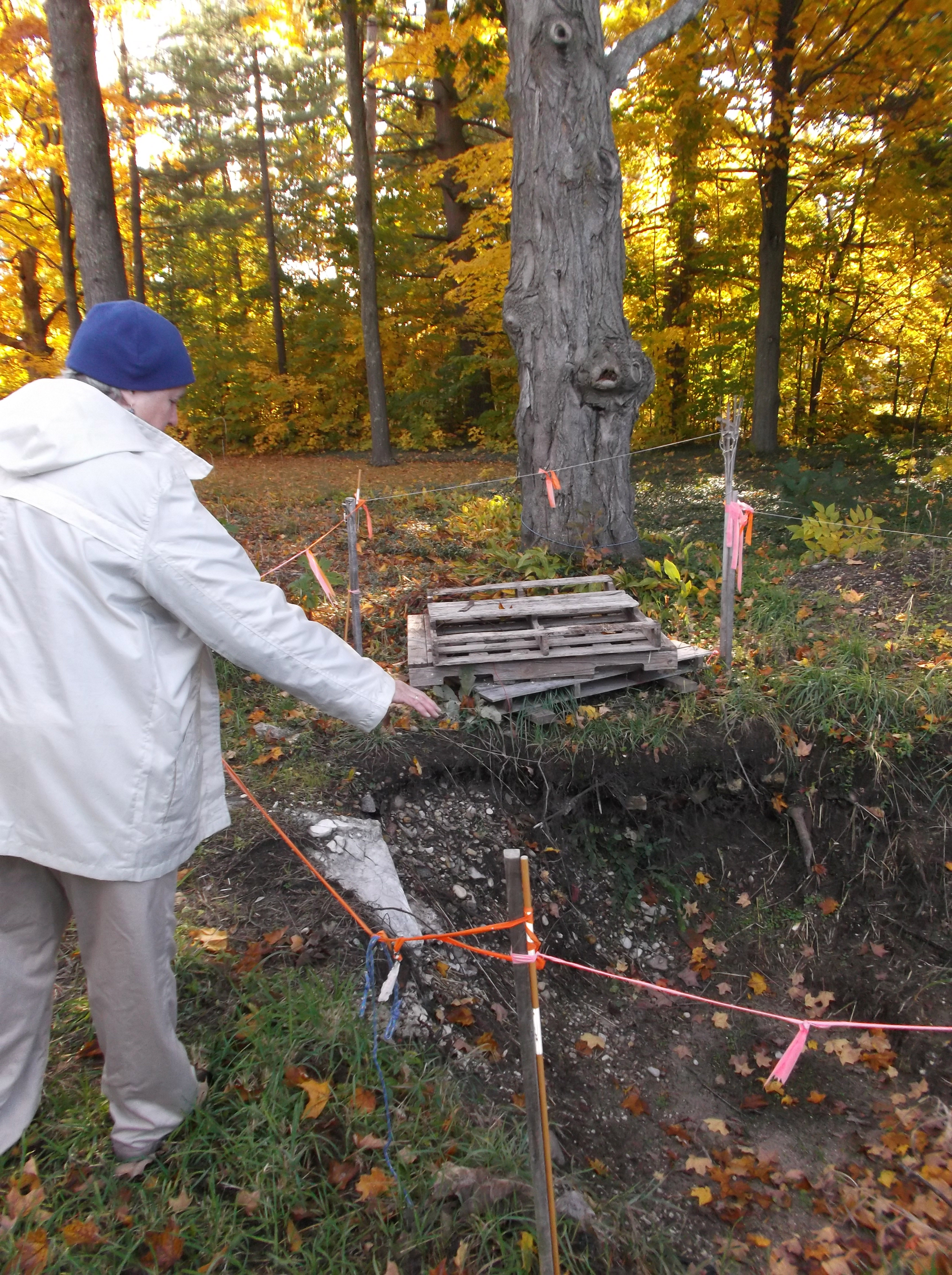
Warne, October 2014, describing the excavation of the privy site. Warne is also involved in the more recent excavation, in June 2015, undertaken by North Central Michigan College professor Kerri Finlayson and her students. Image courtesy of the author.
Nancy Warne’s interest was piqued. While undertaking her volunteer duty of raking the grounds behind the house and buildings of the Dougherty Home on Old Mission Peninsula, she would find an assortment of debris, mostly broken glass and pottery. Her suspicions were further raised, after having watched a program on excavating a historical outhouse site.
What else could be found under the myrtle in the Dougherty/Rushmore backyard? What might be found at the suggested site of the Rushmore outhouse?
A brief, but relevant, digression: Peninsula Township purchased the Dougherty Historic Home Site property in July 2006, in collaboration with a number of concerned organizations on Old Mission Peninsula. The Site is home to the original 1842 structure built by Reverend Peter Dougherty, a Presbyterian minister and missionary. The Mission House “is believed to be the first post and beam house in the lower peninsula, north of Grand Rapids”. (1)Solon Rushmore purchased the property from Rev. Dougherty in 1861, and it remained in the Rushmore family for 100 years. (2)
An archaeological study of the entire home site was commissioned by the Peter Dougherty Society, the organization responsible for restoring the buildings and grounds on the property. When that gridded search came up empty, the Society members figured there simply weren’t any buried treasures to uncover. So what was Warne uncovering during her raking stints? Random refuse? A possible location of an old outhouse?
There was nothing for it: Warne had to know.
Rather than searching blindly, which could compromise the integrity of any historical dig sites found, Warne had some help. Nancy (Rushmore) Hooper, the grandchild of William and Minnie Rushmore who had run the Mission House as a summer inn for visitors until about 1915, knew where the Rushmore privy was located. She had used it as a child during her summers in Old Mission. She recalled during inclement weather running through the house into the summer kitchen and out the door of the woodroom directly to the outhouse.
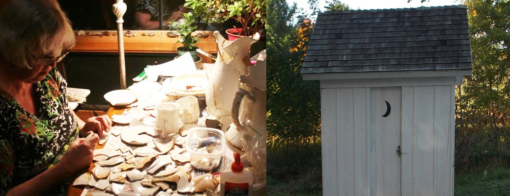
The outhouse was restored in 2009 by dedicated Society volunteers, and other than the roof and 4 inches of treated wood at the base of the outhouse, most of the wood is original. Needed replacement wood was obtained from a collapsed 1870s barn near Bowers Harbor. Original wooden pegs in the window framing and 5 different sized square steel nails from the roof were reused in the reconstruction. The lids are original, as is part of the seat. Sorry folks, this three-holer is for display only. Image courtesy of the author, October 2014.
Understandably, after the Rushmore family purchased the home from Dougherty and eventually turned it into an inn, the first order of business was to move the Dougherty outhouse from direct view of the dining room window and orient the door to face south for additional privacy. That new location was the one Hooper remembered and the one that was excavated.The Mission House was not graced with a full bath until some time between 1930 and 1950. In the 1950s after the site was sold to Virginia Larson, the outhouse was moved to the cement slab where it now stands.
Once plumbing went in to the Home, the privy holes were slowly filled with household refuse. After the outhouse was moved in the 1960s, the holes were further filled with dirt, and myrtle gained a footing, creeping over the site and providing effective camouflage.
Society members are fully aware of what it takes to properly dig a site and restore any findings, so after making an initial, inches-deep search of the spot Hooper identified, Warne called upon experienced archaeological students and Society volunteers who were excited to begin digging. They began digging August 23, 2012, and lasted through the month of October. On that first day, nearly 60 bottles were found. Warne says that, initially, the items were merely cataloged based on where they were found in the dig site, but quickly a more rigorous procedure was developed, as follow-up research would clearly need to be done to do the excavation justice.
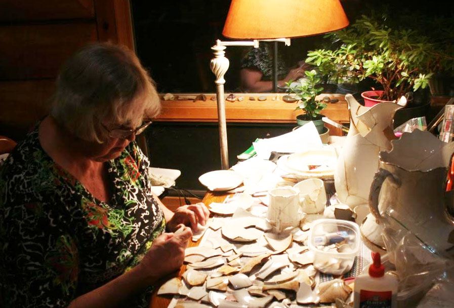
The results? Three to four tubs of disintegrating metal, mostly cans; some intact pieces of metal, including an 1869 shield nickel, a small child’s sterling silver ring, a shotgun barrel; dishes, mostly broken that are being lovingly reconstructed; a Kewpie doll and clay marbles; and most significantly, 280 intact bottles.
After the thrill of excavation, Warne got down to the nitty-gritty of her research. What were these bottles, and what would they tell us about the Rushmore family?
A sample of Warne’s work on identifying and dating the bottles found during excavation. Image courtesy of the author, October 2014.
An introduction to glass bottle manufacturing in the United States, ca. 1860 to 1930, was the first step in dating the bottles. Warne’s primary dating method deals with the seam present on machine-made bottles, which ran up the side and over the rim of the bottle; a bottle-making machine was invented in 1895, and in wide use by 1910. Many of the bottles had manufacturer’s marks on the bottom. With that information, Warne was able to date most of the bottles, the majority of which are machine made. Some of the oldest items were canning jars, dating from the 1870s, complete with common imperfections of the time, such as bubbles in the glass.
One of several displays for the August 2012 privy excavation. Image courtesy of the author, October 2014.
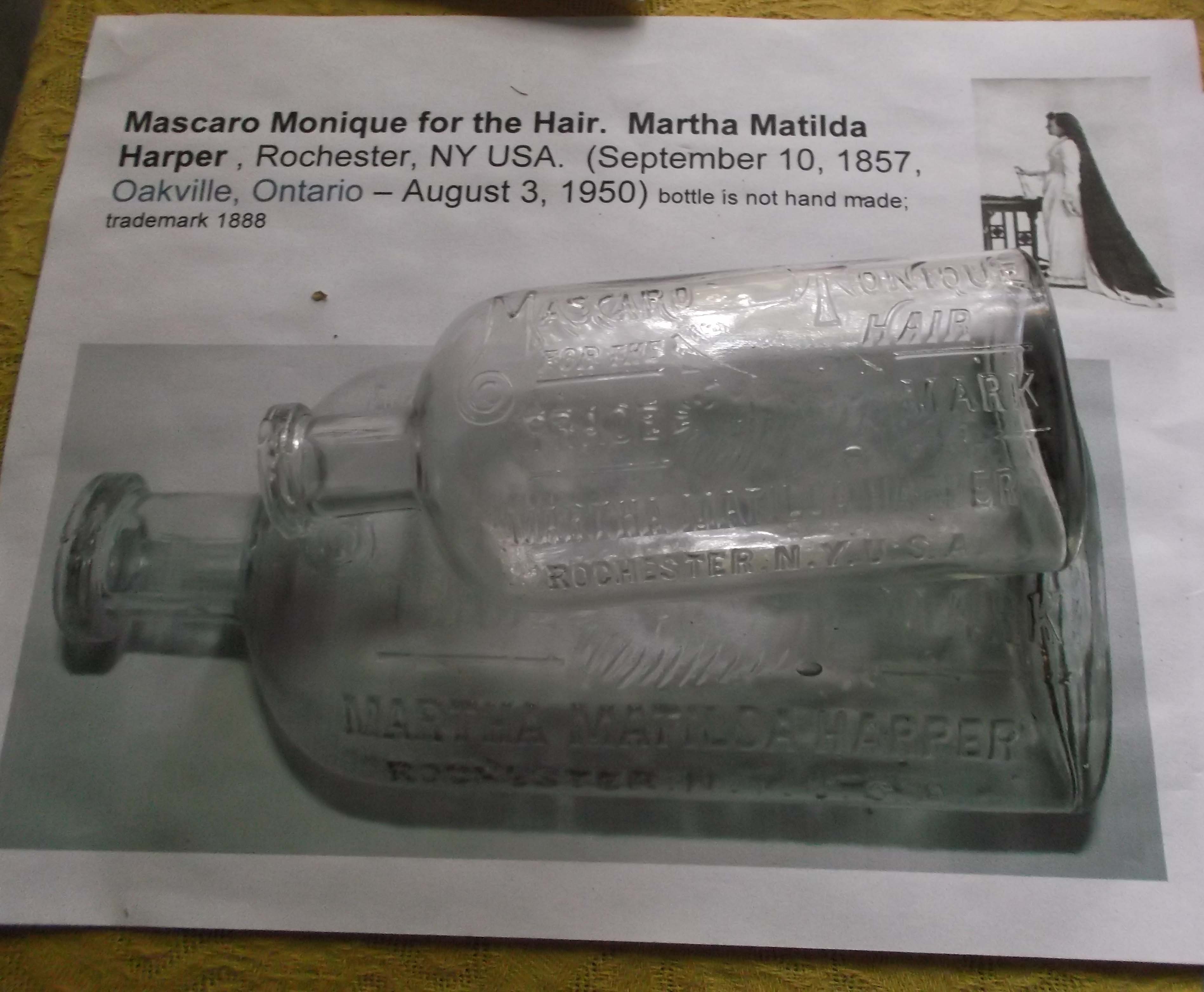
Some of the bottles are of brand names we would recognize, “Colgate,” “Hires Root Beer,” “Listerine,” Alka-seltzer”, “Heinz Catsup”, “French’s Mustard”, “Bromoseltzer”, Carter’s Ink” Ultimately, Warne divided up the collection into Food, Personal Use, Household, Medical (which turned out to be the bulk of the collection), and Miscellaneous. An important local find were bottles from the American Drug Store, Traverse City, Michigan.
When asked if anything really stood out to Warne, she pointed to her favorite bottle, “Mascaro Monique for the Hair” (pictured above), largely for the history of the woman behind the hair tonic. Warne also noted that there were “lots of laxatives. Take that for what it is.”
Warne’s find has been on display in the “kitchen” of the Mission House for the past three years, and as she told me, “seeing this many bottles on display really gives you a sense of the numbers, including the number of hours I spent cleaning and identifying them!” As the restoration of the Home continues, the vision being to restore the interior and exterior back to between 1850 and 1915, Warne’s find is no longer safe in its current space, and will be put into storage. She anticipates that one-third to one-half of the collection will be put back on permanent display, once the restoration has finished. She also curates two annual displays, at the annual Log Cabin Days on the last weekend of June at the Dougherty Home Site property, and at the Woodmere Branch of Traverse Area District Library, usually in August.
Warne, here piecing together pottery found in the June 2015 excavation, in much the same way as the August 2012 finds. Image courtesy of David C. Warne, June 2015.
Warne stresses that the restoration of the Home has truly been a dedicated group effort by all the Society members. “We have experts come in, but most of the work has been done by retired businessmen, teachers, farmers… just people who are really handy.” (3)
This summer of 2015, a licensed archeologist, Kerri Finlayson and her student crew from North Central Michigan College have been digging in the suggested area of the original Dougherty outhouse. Hundreds of small artifacts have been found from a depth of one foot to nearly 20 feet, including an arrowhead, buttons, ink bottle, shoe polish jar, toothbrush, pipe stems, animal bones, chards, etc.
The Peter Dougherty Society continues its work to restore the Home. Many of their restoration projects to this point have been on outlying buildings, including the outhouse, ice house, and summer kitchen. You can help the Society complete the restoration of the Home and establish it as a museum! The Jeffris Family Foundation has awarded the Society a challenge grant of $157,000, to be provided on a 1 for 2 match basis and has kicked off a three year Capital Campaign to raise $314,000 to complete the restoration of the Mission House and establish it as a museum. Fundraising for the matching grant must be completed by December 31, 2015, so no time like the present!
For additional information or to donate, contact www.oldmissionhouse.com, Peter Dougherty Society, PO Box 101, Old Mission, MI49673 or call (231) 223-8778.
Amy Barritt is co-editor of Grand Traverse Journal. Nancy Warne, interviewed for this article, has been an active member of the Peter Dougherty Society since 2005. In addition to discovering lost privy holes, Warne is also responsible for filming much of the restoration projects underway, as well as all pre-restoration documentation, “to record the way everything looks before they tear it all apart,” as she says.
Special thanks to David C. Warne for introducing the Journal to Nancy Warne and her fantastic work, and for the photograph included in the article.
For more information on the “Old Mission” in what is now Grand Traverse County and the “New Mission” in Omena, Leelanau County, check out “History of the Grand Traverse Region,” by Dr. M.L. Leach, from your local public library!
Nancy Warne, Personal Interview, October 2014.
Locally-produced digital magazine featuring nature and local history from the Grand Traverse Region.