Tag Archives: featured

Nelsonville Pavers… now we know!

by Carol Barritt, first-time submitter to Grand Traverse Journal

“Hello editors! I am a reader of the GTJ, thanks for all your work. The Mystery Photo is one of my favorite features. I’m a first-time submitter, and also the proud mother of editor Amy Barritt. The information I uncovered in my research (all online) is amazing. I never learned who chose the Nelsonville Block for our streets, but it wouldn’t surprise me if Mr. Hamilton wasn’t involved. The choice to use them was an excellent one.

The pavers were made in Nelsonville, Ohio. The first plant was built in 1877, closed in 1937. That area of our country has the best combination of raw materials needed to make excellent bricks, especially the clay. I read an article about the brick’s construction. According to the article, it was the “King of brick pavers,” and the salt glazing was the secret ingredient.

Salt glazing, produced by shoveling salt into the fire at high temperatures, gave Nelsonville Block pavers a distinctive finish and made them more watertight. Nelsonville Block won first prize at the 1904 World’s Fair in St. Louis, Missouri, for the way it was made.

You NASCAR fans may be surprised to learn the Indianapolis 500 Speedway race track ended up being paved with the Nelsonville Block. When the track opened in March 1909,  it was originally built out of dirt, 2 inches of gravel, and 2 inches of limestone covered with taroid (a solution of tar and oil). Opening weekend was a three-day event. Each day was a race; by the end of the third race, there had been 6 deaths. The AAA officials stopped the race and closed the track until the troubles with the track (pot holes and ruts) were corrected. My personal thought is, “Potholes? Road building is still trying to solve that one!” By April 1909, the owners, Carl Fisher and partners, looked into pavers. They chose the Nelsonville Blocks. The project began and was ready for racing December 1909. Each paver was hand-laid over a 2 inch cushion of sand, then leveled and the gaps filled with mortar. A concrete wall 33″ tall was constructed in front of the main grandstand and around all four corners to protect spectators. The final brick added to the track was made of gold and laid by Governor Thomas R. Marshall. Locals named the track the “Brickyard,” a name that has stuck throughout the track’s history. Today, 3 feet of original bricks remain at the start-finish line.

Pavers are still used in the building industry, but for constructing a driveway or patio. You can choose between clay pavers or concrete pavers. Clay pavers are longer lasting, chip resistant, hard and brittle, and keeps it color better, but they are more expensive. Concrete pavers fade and discolor, absorb dirt, oil and stains, and are easier to cut and lay. It the pavers are sealed with a quality sealer, they will last longer and are less expensive.

Happy paving! I’m glad the blocks are being salvaged and reused. Little Bohemia used to have some blocks when they remodeled in 2005. Look around the downtown area, and you’ll probably find several places and areas with the pavers still in use. Want to take a drive on pavers? Try Eighth Street between Division and Union. I love history!”

Not Mosses, Not Armed, The Club Mosses of Northern Michigan

Club mosses are not mosses, nor are they armed with clubs.  They are small, however—only a few inches high on average—and are easily missed by hikers and those out for casual walks in the woods.  Like mosses, they reproduce by spores, but, unlike them, they have vascular tissue to transport water from the roots (like flowering plants). 

Lycopodiella inundata, found in local bogs.
Lycopodiella inundata, found in local bogs. Image courtesy of the author.

Most species of club mosses bear those spores on a stalk held above the plant proper, this structure called a strobilus (or, in plain English, a club).  They shed their spores to the wind abundantly in the early summer: Just nudging a strobilus will send a cloud into the air, perhaps a danger to those with allergies, but perhaps not, since tree and grass pollen wreak far more damage.

Lycopodium clavatum. Image courtesy of the author.

Once in our history those spores had economic value.  In the days before photographic flash, photographers would ignite a charge of club moss spores to produce a burst of light.  Glass plate negatives were thereby exposed, making it unnecessary for subjects to spend many seconds in a strained pose.   The spores contained tiny droplets of oil, which instantly caught on fire, much as flour dust ignites in grain elevator explosions.

Most club mosses are clonal: that is, they creep along the ground or else have underground rhizomes that put up new plants at regular intervals.  An old clone can be many meters in diameter.  In Leelanau county I have paced off one clone that occupied a circular space more than 30 feet across.  There is at least one exception to the clonal habit of club mosses, however.

Shining Club Moss, with springboards for gemmae. Image courtesy of the author.

The shining club moss, Huperzia lucidula, grows in clumps, successive plants growing from horizontal stem often hidden under leaves on the forest floor.  In addition to creeping forward in this manner, it spreads in a way that is singularly interesting to botanists and to people that like to play with other living beings.  I count myself among the latter group, having spent many enjoyable hours turning click beetles over to watch them click upright with a bound, feeding ants to ant lions in their dens, and pestering pill bugs until they roll up in balls.  The shining club moss offers as much amusement to me as those organisms do.

In August they have developed tiny springboards among the upper leaves, each one of which equipped with reproductive structures called gemmae, which are capable of growing into new plants.  If you depress the springboard with the tip of a pencil, it will react convulsively, jumping upwards and releasing its gemmae. 

How far do they travel?  The answer is readily available to us.  Look at the clump of Huperzia and see how far the farthest plant lies from the collection that comprises the clump.  It grew from a gemma that was propelled from one of its parents, that plant often two or three feet away.  Perhaps safety glasses are called for when the springboards are springing!

Huperzia is one of a few club mosses that does not bear its spores in clubs.  In late summer you can see tiny yellow bodies in the axils of the leaves, each one a sporangium that will release its spores.  The plant is unique in that way, and will not be confused with other lycopods (a word that refers to this group of plants).  It is a joy to find one growing in a Northern Michigan hardwoods.

That is where I have always found them: a rich forest composed of beech, sugar maple, red maple, basswood, with an understory of ironwood and striped maple.  It prefers a rich soil with a measure of clay.  Some lycopods can be found growing on sterile soil in partial sun, too.  Frequently the naturalist is surprised by their appearance in such unexpected habitats.

Dendrolycopodium dendroides. Image courtesy of the author.

Club mosses have little practical value.  By Michigan law they are protected from harvest by persons wishing to gather them on state land and sell them at Christmas time for decoration.  Apparently, their evergreen branches remind people of cedar boughs at that bitter time of the year.   Some species resemble tiny conifers and are planted in terrariums with varying success.  Dried, they might pass for trees in a miniature railroad layout or diorama.  In any case, they brighten our lives with their curious growth form and unlikely habits.

Richard Fidler is co-editor of Grand Traverse Journal.

Now a Citizen…or Not: A Chinese Laundryman in Traverse City, 1898

The October 13th edition of the Grand Traverse Herald displayed a note about a happy event:

Now a Citizen

Willie Lee, one of the proprietors of the Chinese laundry on Front street, has renounced allegiance to the Chinese empire and has the more effectually severed his connection with his native land by having his queue shorn from his head, which forever shuts him out from within the Chinese domain.  The ceremony was conducted Saturday night in the Hotel Leelanau with considerable solemnity in the presence of several friends and a banquet followed.  The finishing touches to the queue cutting ceremony were effected by Jud Cameron.

Willie Lee is a very intelligent celestial and for a long time has contemplated becoming a full fledged citizen of the United States and has already procured his first papers.

That short note in the newspaper calls up a number of questions.  What was it like to be Chinese in Traverse City at that time?  What about the shearing of Willie Lee’s queue—was that hairstyle really connected with being Chinese at that time?  Did he actually become a citizen of the United States?  Just a few words suggest a big story.

The Chinese in America were regarded as an oddly different kind of human being.  Many wore their hair in a long braid (derisively called a “pigtail”) and dressed in clothes distinctly un-American.  In China the queue was a required style for men and failure to observe the custom sometimes brought punishment.  The curious word “celestial” (a Chinese person) is derived from a name for the Chinese Empire of the time, T’ien Ch’ao, the Heavenly Kingdom.

Star Laundry was a contemporary competitor of Sam Wing Kee's laundry.
Star Laundry was a contemporary competitor of Sam Wing Kee’s laundry.

We learn about the tiny Chinese community in Traverse City at the turn of the century through snippets of text in local newspapers.  Willie Lee was said to be highly educated, the only Chinese person to affect a Western appearance in hair style, clothing, and general appearance.  In 1898 he was said to have visited China for two years, touring the country by bicycle.  Much esteemed by local people, Willie Lee was described as a generous and kind person.  He gave out flower bulbs at Christmas which could be grown in dishes filled with water and stones, and distributed embroidered handkerchiefs among his friends. 

An article dated January, 1909, tells us more about Willie Lee.  We learn he was a splendid cook, especially skilled in preparing chop suey and bird’s nest soup, a delicacy that requires nests imported from China.  Most likely the editor of the newspaper was invited to a New Year’s feast, given the writer’s enthusiastic endorsement of the food. 

The laundry presented a frightening aspect to children.  In 1962 Jay Smith tells about his experience visiting the place in the mid-1890’s:

About the middle of the 90’s of the past century, Sam Wing Kee came here from Chicago and rented a little building about where the Penney Store is now located, and started a laundry.  He imported five or six Chinese men who did the work and the laundry flourished for perhaps ten years.

The Chinese workers could speak no English, wore native costumes and had long braids twisted about their heads.  We recall very well going in there with some older person and looking out in the steamy back room where the laundering was being done, and then being mighty glad to get out alive.  They scared the daylights out of us.

The cachet of foreignness frightened children of the time.  Persons of a different race, different dress, different customs—all speaking a foreign language—made them want to run for their lives out of the laundry.

What happened to Willie Lee? Another article dated six months later informs us that Sam Wing Kee, better known as Willie Lee, after 14 years in the laundry business, sold out to one Lem San of Chicago.  Lee was said to have taken out the necessary papers and become an American citizen, wearing American clothes and cutting off his queue.  His business was successful in Traverse City and he made many friends, his success related to his hard work and earnestness.  The newspaper reports he will return to California and marry “the girl he left behind him,” later planning to attend school there.   

With regard to the marriage, it must have been a long wait for the couple; some 13 years he toiled in a tiny Northern Michigan town as she presumably waited patiently somewhere in China.  Lee would have been in his mid-thirties when he left Northern Michigan.

Image from Frank Leslie's illustrated newspaper, vol. 54 (1882 April 1), p. 96. - This image is available from the United States Library of Congress's Prints and Photographs division under the digital ID cph.3b48680.
Image from Frank Leslie’s illustrated newspaper, vol. 54 (1882 April 1), p. 96. – This image is available from the United States Library of Congress’s Prints and Photographs division under the digital ID cph.3b48680.

Former residents of the Heavenly Kingdom had a hard time in the United States in the latter part of the nineteenth century.  After helping to build the transcontinental railway, completing it in 1868, they suffered a catastrophic defeat in Washington with the passage of the Exclusion Act of 1882.  Passed by politicians responding to widespread hatred of Chinese workers in Western states and elsewhere, this legislation cut off immigration completely from China, even going so far as to forbid citizenship to immigrants already settled here.   The Act was repealed in 1943 when the Chinese were seen as the “good” Asians (as opposed to the Japanese) during the Second World War.

Given the forces working against any Chinese getting United States’ citizenship during the 1890’s, this writer wonders how Willie Lee (Sam Wing Kee) ever became an American citizen.  Was the editor of the newspaper ignorant of the Exclusion Act—or did Willie Lee have special papers made that got him around the brutal effects of the law?  We don’t know.

What we do know is that Traverse City had a Chinese laundry around the turn of the twentieth century, that its proprietor was highly regarded, that he moved away to find a wife and a better life for himself.  With regard to minorities of any kind, Traverse City was isolated, situated far away from larger populations to which minority settlers eventually returned.  The area never had a substantial black population.  Even the tiny Russian Jewish community melted away as children left for other places.  Julius Steinberg’s daughters departed for Chicago, presumably to find husbands of the same religion.   Traverse City never seemed to gain the critical mass required to maintain communities of diverse ethnic background.  Only Bohemian and Polish immigrants stayed long enough to exert an impact on the area.

Still, we wonder what happened to Willie Lee/Sam Wing Kee.  Did he achieve citizenship?  Arrive in California and marry there?  Go to school?  Have children?  We may never know.  Some persons live with us only a short while, only to set sail and vanish.  That is the way it was with Willie Lee.

so with fear hidden and smiles showing—we forded a river!: An Automobile Journey of 1913

(This document is provided courtesy of the Traverse Area Historical Society, 322 Sixth Street, Traverse City, MI 49684)

EAST JORDAN, MICHIGAN TO YORK STATE

INTERESTING AUTOMOBILE TRIP DESCRIBED by Miss JENNIE WATERMAN

In Three Letters published in the CHARLEVOIX COUNTY HERALD

A Weekly Newspaper in East Jordan, Michigan
Mr. George Lisk, Editor and Owner

Detroit, Michigan

August 7th 1913

Dear friends:

There is always a kink in a real trip to start out on, don’t you think?  We wanted good omens, though, so we refused to go back after our lunch when we discovered it was missing, a couple miles out of town.  We left Main Street at 6:43 and made Eastport at eight o’clock.  About twenty more miles brought us to a field of five-inch corn and a corresponding backwardness in other crops.  The hypothesis that last year’s crops had been as poor is all that we could find to account for the straight-tailedness of the pigs in the next fields.

We found teams working on the roads but had no trouble before reaching Traverse City at 9:55, coming into the town along that beautiful stretch of road right beside the Bay which we had seen before only from train windows, and passing the high board fence about the large Fair Grounds.  In Traverse City, Father’s cousin, Edwin P. Waterman, surveyor for Grand Traverse County, made us a plat of the roads we were to follow as far as Manton.  We passed through a storm area just below Buckley.  Buckwheat fields are numerous and flourishing from Buckley and east of Big Rapids.

We made Cadillac, 106 miles from home, at 2:50.  There we separated, Mother and Father going on with Gertrude Bretz to stay the night at her parents’ far home near Evart, and I taking the train for Big Rapids, where I would sign out at Ferris Institute and Eva and I would be packed ready for the next day’s start.  The car made 141 miles that Tuesday for the first day of our trip.

Wednesday morning we left Big Rapids with the entire party of five and paraphernalia at 9:35 a.m.  The things along the road of incidental interest were a young quail, and later a real sauger that had shed its rattles, this being the season for that.  Cobble stone houses appeared often and we think they are fine.  Certainly they had some artistic and comfortable porches.  An unusual number of fine big barns were either just finished or in process of construction, and we had several glimpses of wind-stackers in action.

At Mt. Pleasant we discovered that the valve had been broken off, letting the water out of the cooler, and used three pails of water in cooling the machine down.  Through Gratiot County we saw beautiful level fields and really got to missing our native hills before we struck some slight grades in Lapeer County.  Farming looked pretty prosperous through there, with oat crops especially fine.  At Shepard they were repairing a bridge, so with fear hidden and smiles showing—we forded a river!  It really was an interesting experience, water coming not quite over the tool-box on the running board.  Just about here we passed groups of splendid farm buildings.

We saw a storm ahead of us at 4:30 but it was traveling the same direction we were and we did not overtake any of it but the puddles.  This was along the thirty miles of absolutely straight road between St. Louis and Saginaw which we made in an hour and a quarter.  The farms and the buildings looked poorer from St. Louis on.  We had made 170 miles for the day when we stopped for the night at Mayville.

Our third day started out beautifully.  Everybody smiled.  A farmer with a wagon load of milk cans assured us we were good looking but his horse was afraid of us just the same!  Barley fields were fine through to Brown City.  We found silos quite numerous and they commonly have an octagonal roof which I have never seen up north.

We found a rather faded Stroebel Bros. Hardware sign.  It did not say, but we figured it out to be 328 miles 32 rods from home.  Query—does advertising pay?  A large pig was out in the road as we passed the sign and when we tooted he immediately advanced to meet us and waited in the middle of the road until we stopped the car before deciding in favor of the clover on the right hand side of the road.

We found the clay roads of Lapeer County bad after the storm.  Whenever the roads are bad, we think we must be off the route and stop for instructions.  Conferring with one knight of the pipe—said pipe of unestimable strength—and were recommended in all sincerity to “keep right on the telegraph poles and we couldn’t miss it.”  Mother, of course, held the King’s Blue Book and read off to Father the directions as to “half a mile to a stone-heap on the right, then one mile to the small church on the left before turning east” but even such help had weak points.

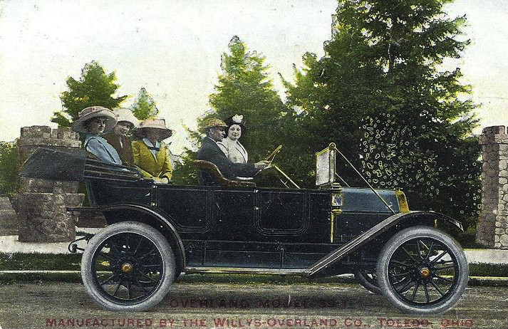
In following local instructions we rode over a clay bump and broke the rear right hand spring on the Overland.  This was near Yale, 38 miles from Port Huron, where we had intended to cross into Canada.  Father found that we could not get a new spring in Port Huron so trailed cautiously on into Detroit shortly after 7:00 p.m.  He has taken the train to the Overland Car Works in Toledo to bring back the needed spring, and we hope to leave dear old Michigan by noon tomorrow!

A punctured tire happened between Mt. Clemens and Detroit.  Gertrude Bretz and I had taken a train from Mt. Clemens to Detroit to lighten the load and so I still have my first tire-experience coming.  I suppose it is safe to say it is coming.

This is rather a bad place to leave the narrative but there’s a better day coming.  And then it is rather exciting, “projeckin’” until you hear next time.  Being an editor, you realize the psychological value of that!

Sincerely,

Jennie Waterman

________________________________________________

Stafford, New York
August 15, 1913

Dear friend:

While the chauffer [sic] is riding around the country with the sheriff (who happens to be in the family) of Genessee [sic] County, we “women folks” are set down on a lovely York State farm long enough to breathe twice.  This particular visit is to last twenty-four hours.  But perhaps you want to know how we got out of Detroit.

When Father came back from Toledo Friday with the new spring the garage people had found a broken casting—which might have been made in an hour by Maplass Foundry—but the original article was preferred and another twenty-four hour wait, it seemed.  At least the garage people thought so.  Mother and we three girls spent most of Friday on Belle Isle and the pleasure boats.  Except for the delay our time and experience in Detroit were interesting.  The all-negro orchestra on the boat Promise had one member with red hair and blue eyes, but the music was wonderful.  But we liked to choose our own ways so pretended to be very bored.

Customs officers are jolly people.  Doubt if they could survive long otherwise.  Getting from the garage to the ferry dock Father got in a hurry and took the turn onto Woodward a few feet nearer the left than the right (both meanings) and a blue-coat inquired where we were from.  We spread the charge as thin as we could by saying “Northern Michigan” so East Jordanites need not feel diffident about visiting Detroit.

The customs officers asked a few questions, gave advice, mysterious papers, and a reduced toll “because of the ladies,” then waved us majestically onto the Excelsior Ferry.  The crossing took five minutes.

Canadian red tape must be stickier than ours, it took so long to unwind, and was it ever hot in that narrow cobbled street between tall brick buildings where we had to wait!  It cost us $14.00 to go through Canada, $4.00 for the licence and $10.00 for bonds–$5.00 of which we will get back when we are home again and Canada is satisfied we did not just drive over to sell our car!  At 5:20 p.m. Saturday we were ready to leave Windsor.  There was some trouble getting onto the right street to “turn this way, then that way, then this way, then that way, until you hit the telephone poles.”  Just out of Walkerville we passed several large fields of tobacco plants and these occurred all along our route through Canada.

We were so anxious to make up for lost time that we drove eighty-one miles before 11:45 when we stopped in Blenheim for the night, pounding on the door and bringing the proprietor out onto a tiny balcony above the door in his nightcap before he came down to unlock and let us in.

Next morning we found the dining room, and our good breakfast, decidedly English.  Where in the U.S.A. we have mirrors and out glass and flowers, they had copper platters, queer spears and arms.  Three great tusks of elephants decorated the sideboard.  It was raining when we left Blenheim and rained by spells until late afternoon.  The worst of the storm was east and south of Blenheim in the country through which we had to go.  Corn and grain were laid flat or standing in great lakes of water.  The clay roads were really dangerous.  The car slewed dreadfully even with the chains on.  At Ridgetown we were warned of a formidable hill which we might not be able to make.  But because we are from Michigan, Canada has yet to show us any hilly roads.

At London we stopped for dinner.  Since it was Sunday everything was closed tight, with the exception of one large Chinese restaurant.  There we were smilingly offered “Sli” tomatoes, green peas, Flench flied potato, yah!”  We ordered and then Mother led us determinedly back to the kitchen to wash our hands.  Such a kitchen, with drifts of vegetable peelings on the floor.  But the dinner still tasted good.

The favorite salutation in Canadian rural districts seemed to be “Hello, Jimmy!”  Names of towns, Highgate, Strathburn, Thamesford, Lambeth and Burford, sounded English enough and just fitted the scenery which looked the original of little English prints we have seen of the Avon and Thames.  By the way, we crossed the Thames rive three times and a muddy stream it is.  We have not seen, either in York State or Canada, a clear, clean stream such as we find all through Northern Michigan.

Coming out of London we passed Kellogg’s Toasted Corn Flakes building.  From there to Brantford we took the Governor’s Road and I am sorry for the Governor and all Canadians.  Just out of Brantford, two hundred six miles from Windsor, we saw the first speed limit board we encountered in Canada.  Father declared some of them we saw later were not on his speedometer.  Out of Brantford and after dark, we came up against our sixth washed-out bridge.  We slid down a clay bank, wallowed across a clay swamp, and after unloading—first time on the trip—eight men pushed the car up the further bank.  Mother ungratefully told them she did not like their country.  We passed a Ford in the swamp, stuck with a broken spindle.  We made it into Hamilton after a couple miles of winding road, down which the car coasted.  Clay roads are bad for tempers and we were glad to stop for the night, having a mileage for the day of one hundred and forty-nine miles between 9:45 and 10:00 p.m.

Monday morning the sun was shining on the town of Hamilton, gloriously decorated for a Commerce Produce Industry Centennial 1813-1913.  We had beautiful views of hills to our right for twenty miles or more.  Through there is a great fruit country and we passed grape vineyards in plenty.  Here we had a mighty interesting three-cornered race with a motor cyclist and an interurban limited.  Beat them both on a five-mile stretch.

Just out of St. Catharines we stopped and watched two big Lake barges being locked through the Welland Canal.  Seeing it straightened out our ideas of locks beautifully.

niagarafalls

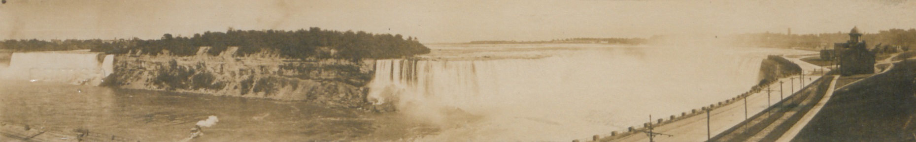
My first glimpse of Niagara Falls five years ago was from the train on the Canadian side, and this time we drove the car along the edge for half a mile, nearly up to St. Anthony’s Falls and back.  The view of the Horseshoe Falls is much better from that side.  The spray for a couple blocks is like a heavy rain so that we ducked under the blanket and peeked out, for the speed limit of four miles is rigidly enforced, rain or shine.

We had made two hundred and eighty-two miles in Canada when we tied on our Michigan pennant of blue and gold, attended to red tape at the Canadian end of the bridge, paid 10 cent toll and crossed into the U.S.A. at 12:10 Monday noon.  The Customs officers looked at our papers, made us a lot of bother getting suit cases untied from the car and then let us go without the satisfaction of being examined.  That is because Michigan people look honest.  We turned into the park and started to leave for the nearest observation point, when a policeman demanded to know where our U.S. car license was.  We declared it was on the back of the car under the mud but we had to scratch it clean and show him before he was mollified.  He was quite indignant that we should expect him to recognize the Canadian license for a minute.  He even recommended that we better run in somewhere and tet the car cleaned up—before we got hauled in!  Honest, you would have thought it a gray car a rod away—so completely smeared was it with clay-mud.  We spent two hours wandering around the Falls, with the air clearer and the sun brighter than I had ever seen it there.  We girls saw enough amusing honeymooners so that we all vowed Niagara Falls would NOT be on our wedding trip itineraries, anyway.

Passing through Tonawanda we saw the Kelsey Hardwood Lumber Company’s office, and five acres of lumber yards which had burned over recently.  We had ten miles of brick pavement out of Buffalo.  The rest was state road, and we made the last forty miles to LeRoy, New York, in an hour and forty minutes.  We have not had a foot of clay so far in the States.

Michigan used natural resources in her root and stump fences.  Canada had wire fencing and white painted posts almost entirely.  York state has stone fences.

This morning we visited the State Fisheries at Mumford.  Not as well stocked at present as they have just made their largest shipments of fingerlings for this season.  From there we drove to Lime Rock Stone Crusher.  The manager conducted us all around and explained things to us—above the frightful roar of the machinery.  The seams are eighteen feet deep.  Each drill makes 115 feet a day, going down from six to eight feet apart, and is driven by air compressed in the main plant and conducted through pipes all round the quarry.  The crusher takes rocks up to three feet in diameter and they come out on an endless chain cobble-stone-size and part are crushed smaller.  The lime rock is too hard to be used by the chemical plants and its main use is in building railroad bed and highways.   This plant is the largest of its kind in the world, turning out 3500 tons a day, working Sundays but not nights.

The total for the trip from East Jordan to LeRoy, N.Y. was 808 miles.  We were on the road five days and had only one rainy day.  The collapsible car top of the car looks so exactly like buggy tops that Father announced they were just for putting up if it rained.  We all became expert at unfolding and extending it when showers began, and at unstrapping, collapsing and tucking it back into its boot when the sun came out again.  Consequently, we four women folk arrived at the wedding of our cousin last Tuesday with badly sunburned noses.  But that was a small matter.  Our party left LeRoy Tuesday morning in a Buick and our Overland.  Toledo cousins here on their own motor cycle honeymoon accompanied us.  At the end of the day they proceeded on their own trip to New York City and Boston.  The wedding was on the lawn under the giant locust trees beside the hundred-year-old cobble stone home of Father’s older sister, Martha Paine.

The new bridal couple left in our Overland with Father taking them to the boat at Buffalo, where they embarked for Cleveland and the new home.  We expect to call on them on our way home through the States.  Our present plans are to get us on our return way Monday, August 18th, and we will make calls on friends and relatives in Toledo, Cleveland, Kalamazoo and Grand Rapids.  I certainly is proving a wonderful trip.

Sincerely,

Jennie Waterman

———————-

WATERMANS FINISH A DELIGHTFUL AUTO OUTING TRIP
East Jordan, Michigan
August 27th 1913

Dear Friend:

The return trip began Monday the 18th at 8:10 a.m. from LeRoy, New York from the home of Father’s younger sister, Rena Goldsmith.  With fine roads and beautiful scenery we came into the vineyard country between Buffalo and Westfield.  Grape vines were heavy with fruit on both sides of the road.  Here, too, we had dangerously winding roads and went over the first real hills since leaving East Jordan.  We came into Westfield at 4:30 with a flat tire.  Decided to stay for half an hour to have it vulcanized—and stayed half an hour at a time until 8:30 when we decided to put up for the night.  Another auto party were victims of the same garage—their car was overheated and behaving unpredictably—and we condoled with each other while the mechanics experimented.

People in cars from West Virginia, Massachusetts, Nebraska and California, Chicago and Cleveland met us and we hailed each other joyously when we sighted pennants.  Some of the cars had more pennants on than we did—but always the home state pennant was proudly across the windshield, and after all, Oklahoma and Michigan could be close neighbors if they met way out in York State!  It was no trouble at all keeping roads out East for sign boards and danger markers are put up by the Buffalo Automobile Club in New York and western Pennsylvania and by the Cleveland Auto Club in Ohio.  We crossed the New York and Pennsylvania State Line 13 miles from Westfield, N.Y. and 3 miles from Northeast, Penna.  Tuesday morning at 9:17 we had another punctured tire.

Just at the end of Girard’s main street the road dips and curves to cross a bridge over a deep gorge.  There we had a grand, wide viw of the most picturesque country we ever saw; steep cliffs, a winding stream and bands given over to hot house uses.

We crossed the Pennsylvania and Ohio State Line two and a half miles from West Springfield, Penna and one and a half miles from Conneaut, Ohio.  From Conneaut to Ashtabula it was level country.  At Ashtabula we hung up our latest pennants and while Father took the tire to be vulcanized we located a restaurant and ordered dinner.  The second course was being served when it occurred to us to take account of the cash in our four purses.  We found the grand total to be twenty-three cents—even Gertrude B. had given her money to Father for safe-keeping!  But Father came just then.  We were delighted that he had found the same restaurant that we had for the food was very good.

Ashtabula is the largest iron ore receiving port in the world.  While we were waiting for the tire we drove down to the ore loading locks and watched a vessel being unloaded.  The machinery was wonderful.  A great crane lifted an iron ore car, swung it through the air, poised it over a larger car, dumped it and put it back on the tracks.  Jack-knife drawbridges were in action, too.  Later, near Painesville, we saw an immense bridge and went under it through a fifty-foot tunnel.

Nearing Cleveland they were tarring the roads, which should be a good surface against dust for cars.  We were looking for the newlyweds in their apartment on 92nd just a couple blocks off Euclid.  But only 91st and 93rd showed as leaving Euclid.  We asked a sulky drayman the way once, and then went around and met him face to face again.  He need not have been so mad, though.  He shook his fist in the direction we were to go then ordered us to follow him.  We did, very meekly, and reached our port.  92nd started at a Y after 91st and 93rd had gone parallel a couple blocks!  Ruth and Howard were looking for us, and we had a pleasant day in the nation’s 6th city.  When we were ready to leave next morning Howard drove the machine fourteen miles to the city limits and we went on our way rejoicing as long as the good roads lasted.  We were told fabulous tales of “elegant asphalt and brick all the way to Toledo” but we did not find it.  And we had a record of three punctured tires for the day when we drove into the Overland Company’s garage in Toledo at 10:30 that night.  We spent the night at the home of Charles Waterman, Father’s cousin and the tallest of the Waterman men, by the way.  Repair work on the car gave us time to make other calls and to visit Tedke’s big grocery with its foods from all over the world dramatically displayed.

Friday Gertrude B. left us for visits on the side and we four went on to Galesburg, Michigan, where Mother’s people are.  Coming through Battle Creek we were delighted with the decorations for Home Week.  Several cars were beautifully trimmed.  The prize float was white and yellow.  The clown float was a sulkey and horse driven by a clown.  A sign “Please Excuse Our Dust” hung a the back and his license card read “41,144H”.  With our brightly colored twenty fluttering pennants we should have entered the parade ourselves.  Of course the parade marshall might have suggested that we wash off the clay first!

Saturday night we had an auto party dinner with friends in Kalamazoo and went on to Breedsville where we visited old friends of Father’s who had all played in the famous Breedsville Band with him before he and Mother moved north.  Sunday we reached Jenison Park by way of South Haven and Saugatuck over indifferent (bumpy) roads.  From Holland through Grand Rapids to Big Rapids we had the very best roads of all—and then corduroy with all the “brass tacks” in evidence.  I was left off at Big Rapids to attend to trunks Eva and I had left there from our summer course at FI, and the others again spent the night at the D.A. Bretz farm home near Evart.

Tuesday there were just three to make the last start and home run.  The morning starts have been interesting all through—eighteen in all for the twenty-one days out—so we feel we have a welcome left for another time, most places.  I gathered from comments, that it was pretty dark at 9:24 that night when the folks rolled up Main Street in East Jordan, so nobody saw the treasured pennants on our return.  They came off before the usual Sunday drive.  The milemeter registered 3600 miles on arrival.  The reading three weeks ago was 1582, making the trip 2018 miles.  Going was 818 miles, returning 1200 miles.  Now that we are away from the dusty heat and excitement we are enjoying our beautiful trip all over again and planning how we will go next time.  In the meantime it is wonderful to be at home in East Jordan, Michigan.

Sincerely,

Jennie Waterman

Written in pen:
Mrs. Clayton L. Arnold
623 Washington St.
Traverse City, Mich.
1955

Note: This account was written when Jennie Waterman (Arnold) was twenty years old.  It was published previously in the Charlevoix County Herald, and in Michigan History magazine, 1950.

Sailing Portage Lake: 108 Years of Pabst Cup History

By Stewart A. McFerran, Benzie resident and regular contributor to Grand Traverse Journal

City of Manistee resident Frederic Ramsdell (son of Thomas Jefferson Ramsdell of Ramsdell Theatre fame) and others founded the Onekama Sailing Club in 1896. It had a club house, served meals and had sleepovers. The Club’s small sailboats became known as the Mosquito Fleet.

Onekama Sailing Club in August 2014, right. High school juniors Sarah and Katie race to the finish last year, but lost to Bob Beal by one-half of a second.
Portage Lake Yacht Club in August 2014, right. In this photograph from last year’s race, teens Annie of the United Kingdom and Maggie of Onekama made a valiant run, but lost to Bob Beall by one-half of a second. Image courtesy of the author.

The Onekama Sailing Club, now the Portage Lake Yacht Club,  was one of the first sailing clubs in Michigan. The members hand built wooden sailboats that were rigged for racing. “Sundays and holidays were racing days. Races were started in the forenoon. The course was marked by flagged buoys and competition was keen.”*

When the Mayor of Chicago, William Hale Thompson (who served in that capacity in 1915 to 1923 and again in 1927 to 1931), arrived at Portage Lake, the Onekama Sailing Club was uniquely positioned to receive him. “Mayor Thompson of Chicago always received a three-shot cannon salute. His yacht carried a large assortment of grog, and he was a most liberal dispenser.”* Considering he was running Chicago at the height of Prohibition (1920-1933), perhaps we should not be surprised.

Yep, that Pabst. The beer voted the best at the Columbia World's Exposition in 1893. Frederic Pabst celebrated by tying a blue silk ribbon on each bottle, and ramped up production.
Yep, that Pabst. The beer voted the best at the Columbia World’s Exposition in 1893. Frederich Pabst celebrated by tying a blue silk ribbon on each bottle, and ramped up production.

Traditionally, sailing cups are named after the person who commissioned the cup’s creation, or at least donated the funds to have one made. Gustav Pabst (son of Friedrich Pabst, the man who made Pabst Blue Ribbon beer famous) crossed Lake Michigan from Milwaukee to attend races of the Portage Lake  “Mosquito Fleet”. As a supporter of small boat races, he had a large silver cup made. The Pabst Cup was first awarded to the fastest Onekama sailor in 1907. The Pabst Cup Race is still held on Portage Lake each summer, making it one of Michigan’s oldest sailing competitions.

High school senior Bob Beall won the Pabst cup in July 2014 by one-half second! Bob’s grandmother, Char Jesson, has a sunfish he uses for the races. Sailing just behind him  were juniors Sarah and Katie.  Bob also has stiff completion from former winners of the Cup who enter the race every year. All previous winners are listed on the Cup, back to the first winner in 1907.

Veteran sailors Bill Vaughan, Dick Forwood and Biff Wiper have competed in the Pabst Cup for decades. Bill Vaughans’ first Pabst Cup win came in 1964. Most recently he won the Cup in 2012.  Past winner Vaughan has enjoyed an advantage: his wife, Babs, knows how to operate the Club Cannon. She once blew a hole in the sail of a competitor. She claims it was a mistake.

Sailing for recreation remains a popular activity in Michigan. Competitions are often celebrated with trophies. There are very few sailing trophies in Michigan that are older than the Pabst Cup. A contemporary to the Pabst Cup is held by the Bayview Yacht Club, Detroit, Michigan. John C. Burke, Commodore of the Bayview Yacht Club, traces their cup’s history back only to 1936, although the cup is likely older than that: “The J.L. Hudson Trophy is a perpetual trophy that was deeded to Bayview Yacht Club in 1936 by James B. Webber, who was at the time, the Vice President of the J.L. Hudson Company”. *

Bob Beall (right) receives the Pabst Cup from PLYC Commodore Richard Verplank in August 2014.
Bob Beall (right) receives the Pabst Cup from Portage Lake Yacht Club Commodore Richard Verplank in August 2014. Image courtesy of the author.

The competition during the Pabst Cup Race on Portage Lake is still keen after more than 100 years. Bob Beall will need to practice his sailing skills and tune his rig if he hopes to take the Pabst Cup home once again this summer. The race will be held August 1st and 2nd.   There will be three races on Saturday and two on Sunday; the winner will be the sailor that has the best cumulative score. Good luck, sailors!

*Quoted from Wellspring, a collection of short histories on social customs and life in Manistee County, written by students of Onekama Schools, published in 1982. Copies are available for purchase from Manistee County Historical Society.

S.A. McFerran serves on the Portage Lake Yacht Club committee boat and sometimes rescues sailors in need of help.

Celebrate a “Halladay” during National Fishing Month!

Out in the little village of Mayfield, Grand Traverse County, is Mayfield Pond and the Halladay Family Memorial Park. An annual June celebration in Kingsley, just south of Mayfield, honors a particular event that took place at the Pond in the 1920s.

Do you know what happened at Mayfield Pond? Your hint: Leonard (Len) Halladay, and his good friend Judge Charles Adams, were both involved… Len was the local guide, and Adams a visiting enthusiast of a particular sport. He practiced his sport most frequently on the Boardman River and Arbutus Lake.


Dance All Night: The Magic of Fairy Ring Mushrooms

Fairy rings- circles of mushrooms growing in yards are known—and sometimes respected- by both children and grown-ups.  “Respected” because, according to Irish and Welsh legend, they are places inhabited by the wee folk, fairies and leprechauns.  Within the circles they dance, sometimes enticing a human passer-by to join them, much to his eventual regret.   Once inside the ring, he cannot get out and is compelled to dance until exhaustion and death carry him away.  Fairy rings deserve respect: it is at your own peril if you enter them.

Image of Fairy Ring, composed of Marasmius oreades. Image courtesy of Steve Trudell, http://www.timberpress.com/author/steve_trudell/1457
Image of Fairy Ring, composed of Marasmius oreades. Image courtesy of Steve Trudell.

Many kinds of mushrooms form fairy rings, but the commonest is probably Marasmius oreades, the fairy ring mushroom.  It has an off-white cap with widely spaced gills, a slender fibrous stalk without a ring, and white spores.  Unlike most mushrooms which decay and rot over time, Marasmius mummifies in summer heat, shrinking to a fraction of its fresh size, its firm flesh becoming tough and leathery over time. 

If a fresh rain falls upon the mushroom, it perks up, expanding to its former size and regaining its firm texture.  Not only does it appear to resurrect itself, it actually does that very thing.  It has been shown that Marasmius oreades resumes its life processes, respiring and consuming food, even producing new spores on its gills.  Somehow it goes into suspended animation for as long as a summer drought holds on, only to continue its business when growing conditions improve.

One hypothesis explaining the resurrection is the presence of a special sugar within the flesh of the mushroom, trehalose.  After a dry spell, rainwater is absorbed, thereby dissolving the sugar–which enters cells, reviving and stimulating them to divide.  This Marasmius is considered edible (but not especially delicious), having been incorporated into recipes for omelets, gravies, and even chocolate chip cookies.  Perhaps the trehalose sugar helps the cookies taste better, though I suspect that the best change to the recipe would be to leave the mushrooms out.

The Fairy Ring Mushroom, Marasmius oreades. Image courtesy of Les Chatfield, https://flic.kr/p/8FsBM6
The Fairy Ring Mushroom, Marasmius oreades. Image courtesy of Les Chatfield.

Marasmius oreades grows in circles for a very good reason.  It starts out when a mushroom spore lands in a favorable place for food, decayed matter underground.  It spreads out a net of slender cells, hyphae (collectively called the mycelium), eventually reaching a size large enough to send up its first fruiting bodies, the familiar mushrooms we see above ground.  Year by year the mycelium grows outward, forever producing new crops of mushrooms at its outer margin.  The circle gets bigger, five feet in diameter, then ten, then even larger—certainly big enough to accommodate a large band of dancing fairies and an occasional hapless human.

Within the circle the grass may appear yellow and exhausted: the mushroom has absorbed nutrients in the soil, while at the edge it may be green and luxuriant as nutrients are released to be absorbed by the fungus and neighboring grass plants. Overzealous yard managers sometimes try to get rid of the circles of mushrooms, preferring the monotony of turf to the disorderliness of fairy ring mushrooms.  They are seldom successful.

To end this piece one can do no better than to quote a poem about fairy rings, this one unsigned:

If you see a fairy ring
In a field of grass,
Very lightly step around,
Tiptoe as you pass;
Last night fairies frolicked there,
And they’re sleeping somewhere near.

If you see a tiny fay
Lying fast asleep,
Shut your eyes and run away,
Do not stay or peep;
And be sure you never tell,
Or you’ll break the fairy spell.

Richard Fidler is co-editor of Grand Traverse Journal.

Down the Road of Life We’ll Fly: Retracing an Auto Tour From 1920

As a fumbling collector of automobile-related relics, I had long wondered why I couldn’t get road maps before the 1930’s.  It took some time for me to understand that the folded maps offered free by the oil companies—Gulf, Shell, and Mobil—didn’t come out until the thirties.  Before that time, I wondered, how did motorists navigate the highways in the first three decades of automobile travel?

titlepageMy discovery of the Automobile Blue Book answered the question.  Not to be confused with the Blue Book that gives the cash value of automobiles, the Automobile Blue Book was a navigational aid to motorists at the dawn of the automobile age.   Through primitive maps and step-by-step written directions, it outlined routes from one destination to another, Traverse City to Benzonia, for example, or Traverse City to Old Mission.

Blue Books contained much more than directions about how to get from one place to another: They offered information about roads (dirt, gravel, crushed stone), steep grades, and blind curves, and recommended the best and safest routes to drivers and navigators.  Along some roads they cautioned travelers about boulders and washed-out places.  With the unreliable machines of the time, information about garages and hotels was included within the directions: A breakdown requiring repairs and an overnight stay could occur anywhere.

trip-genderSuccessful auto trips required two partners—the driver and the navigator–since the driver cannot take time to keep looking at the book and the mileage while avoiding oncoming traffic, cattle blocking the highway, or ditches that loomed on either side of the road.  An advertisement for a celluloid protector for the Blue Book showed a man in the driver’s seat with his spouse alongside, patiently (we would presume) giving instructions to her husband.  Of course, women drivers were not unknown in the twenties either, and roles could be reversed.

At first, most cars lacked odometers altogether; they had to be purchased as an accessory.  A starting point from each city center was designated—in Traverse City the junction of Union Street and Front served for all routes.  Mileage was zeroed out at that point, all subsequent turns and landmarks measured in tenths of a mile. Like a modern GPS system, the navigator informed the driver of the route ahead, turns and distances, presumably in a calm voice that did not betoken a lack of confidence in the driver.

The Blue Book educated travelers about the areas to be explored.  Of Old Mission Peninsula it generously wrote:

Grand Traverse peninsula [sic] extends 18 miles into Grand Traverse bay and varies from one to three miles in width and in height from bay level to several hundred feet.  With its rugged shore line, many promontories, sandy beaches and sheltered bays, it is the most beautiful region in southern Michigan.

One can imagine travelers from remote places reading the Blue Book to educate themselves about the places they passed through.  It was far more than a navigational aid: it was a book full of answers, much as our internet toys are now.

Upon receiving my Blue Book via an internet sale, I resolved to set out on a journey to catch the flavor of auto travel in the 1920s.  Of course, it wouldn’t be the same: my Honda with its climate control system, stereo radio, comfortable seats, and relatively noiseless and dust-free operation would not capture the same sense of adventure (which, no doubt, was associated with the likelihood of misadventure) that motorists felt so long ago.  I would not have to stop to fix flats as auto travelers frequently did in that era, in part because horseshoe nails no longer littered the roads.  Highways and byways would be paved and smooth without the hazards of poor design, hasty construction, and the absence of highway warning signs (which hadn’t been standardized yet).  In case of an accident I count on four air bags deploying at once while a Model T lacked seat belts and the advantage of a cabin protected by a cocoon of metal that can withstand crashes at 40 miles per hour.  Perhaps all of that safety gear was not necessary given that the speed limit in Michigan and practically anywhere else in the country was slower than a horse’s gallop, 25 miles per hour.

One of my Backspacer friends (the Backspacers are a tiny group of persons interested in local history), Marly Hanson, agreed to act as navigator during our journey.  Possessing the preciseness of mind and the devotion to detail of a former reference librarian at the Traverse Area District Library, she was well suited for the job.  While we were never in danger of getting lost, we would often have to make sense out of outdated instructions.  After some consideration, we decided to go to Leland by way of Suttons Bay and Lake Leelanau, a short jaunt that could be done in a couple of hours or so.  And so, with Blue Book in hand one early September day, we set out on our adventure.

We zeroed out the odometer at the corner of Front and Union in front of the 5/3 bank, already feeling a sense of connectedness to our history since a bank had stood there in 1920, the Traverse City State Bank, founded by Perry Hannah, one of the founders of our town.  However, we quickly realized that the Grandview Parkway did not exist at that time, an extended Bay Street carrying the traffic towards Leelanau county.  Still, odometer readings were in fairly good agreement with the book as we crossed imaginary railroad tracks—now the TART trail—as we passed 72 which led up the long hill to the west of town.

At 2.6 miles we were told to turn left, onto what is now Cherry Bend road, and this we did.  A church was at the corner as indeed it was the West Bay Covenant Church.  We expected to turn away from the bay here since the road from Traverse City did not proceed directly to Suttons Bay as it does now.  It went inland and rode the ridge high up from the water.

At approximately 9.7 miles we passed through a 4-corners with school and church—now Bingham–those buildings having been converted to the township hall and to a residence respectively.  It was a straight sail to the end of the road and a large brick church, St. Michaels, in Suttons Bay.  The trip had been easy so far, the roads no longer gravel but paved and straight for the most part.  Old maples lined the highway, still standing after having been planted by local farmers ninety or more years ago.  They were showing signs of age, premature aging, perhaps, due to the salt applied in winter.

Pages 931 and 932 of the Blue Book, detailing trip author took.

The entrance to Suttons Bay was different from now, the old road joining up with the modern one before the fire station which still stands, though now converted to a restaurant.  Resisting an urge to spend time in the village, we proceeded out of town, up a “long, winding grade”—surely a staggering job for the engine of a Model T laboring to bring the car through gravel on a hot summer’s day.  Reaching the top, we settled down for the long descending trek towards Lake Leelanau, that name being “Provemont” in 1920.

Before we crossed the channel, we read a cryptic note: “4-corners; turn diagonally left.  Cross channel connecting Lake Leelanau 4.3”  The 4-corners still remains, but there is no possibility of a diagonal left turn: the bridge extends straight-ahead.  Leaving town, we see that Main Street crosses our highway: Could it be that the bridge had been moved to the north, separating “Main Street” from the passage across the narrows?  We would learn more on our return.

Leland at last!  We turned right, away from the waterfront to the center of the village, presumably a plot of land where the courthouse stood.  Fairly recently that institution has been moved outside the village to a location along the road we had just traveled.  Forlorn as if awaiting its possible demise, an old brick building with barred windows stood in a mowed field–the county jail–a vestige of the rule of law in this place.  The center of town has moved from here to the busy commercial strip along M-22 and in Fishtown.

Marly and I stopped to get lunch and serendipitously met a friend, David Grath, who had information that would help us understand the mysterious directions given us in Lake Leelanau.   Attracted to this area as a youth, David has explored the northern parts of Leelanau county since 1957, using his geographical knowledge to build an international reputation as a landscape painter.  Keenly interested in local history as well, he tells us the bridge has been moved some time ago to the north.  “If you go down by Lake Leelanau St. Mary’s cemetery to the dock extending into the narrows and look down, you can see the concrete slabs that made up the foundation of the old bridge.  Main Street, used to be the main drag through town, only after they built the new bridge, it became a side street.”

We got in the car and returned to Lake Leelanau, eager to see if evidence of the old bridge can still be found.  We passed the school and wound down a moderately steep hill to a dock that extended into the narrows.  Walking out on it and looking down into the water, we saw slabs of concrete, surely relics of the 1920 crossing.  The road on the other side would have had to bend diagonally to meet the bridge as the directions declared.  Upon reaching the west bank, Main Street would have carried traffic through the tiny town: only a store and post office were mentioned as landmarks to look for.  The post office is now gone, having been moved across the highway to St. Joseph Street, though a small frame building looking old enough to serve as “the store” remains.  Provemont—Lake Leelanau—was not a major stop for travelers in 1920 or in 2014.

So it was that we completed our day of travel following directions given in our Blue Book.   Without need of wiping the dust from our faces or the perspiration from our brows, we returned to Traverse City the direct way, along the Bay.  Our journey was without the romance of early automobile travel, but still provided the smallest glimpse into how motoring used to be.  We decided we would plan another Blue Book guided trek to a new destination in coming weeks.  Who knows what relics of history will be illuminated in that adventure?

Note: Readers may visit the Woodmere branch of the library to inspect this Blue Book in the Nelson Room.  Pages may be photocopied for those wishing to plan an expedition using Blue Book instructions.  Happy motoring!

Richard Fidler is co-editor of Grand Traverse Journal. The image within the header is of Provemont, the “ghost town” of Lake Leelanau, and the steamer SS Leelanau, ca. 1908; Image courtesy of Don Harrison, Up North Memories, https://flic.kr/p/s6YaBg

What Goes Up Must Come Down: Life in Benzie County

(This article continues a series. Please see the third and second place winners in previous issues of Grand Traverse Journal).

By Genevieve Pomerleau (center), First Place winner in the 2015 Bruce Catton Awards

Go into Frankfort, Michigan, turn west on Forest Avenue, then make a right onto Michigan Avenue, and keep going north until you reach Nipissing Street. Once you’re there, make a left and go to the end. Look to your left, and you’ll find a set of small, mossy stairs that lead to the beach. Go down the steps and walk alongside the water for a short ways north. Eventually, you will come across a small stream coming down from the sloped ground on your right.

In the summer of 2008, when I was seven years old, my brother, our friends, and I spent most of our time at Frankfort’s Lake Michigan beach there, at the stream. We would use the mud to make dams in the stream, then break them up and try to get the water to flow all the way to the lake, and we would climb up into the woods and make forts out of old logs and fallen tree branches.

One day, my friend, Ted (who was ten-years-old at the time) suggested that we climb up the hill- following the water- to see where the stream originated. We positioned ourselves on the right side of the small creek and started up the crumbling clay to the next flat area we knew of.  In hindsight, we probably should have climbed on the left side so that there would have been more trees and bushes to hold onto for support. It wasn’t a very far distance, but when you’re a small child, everything seems a lot larger.

When we reached the miniature plateau, we spent a few minutes trying to get onto the flat ground. A large branch that had fallen a long time ago had caused a buildup of dirt and clay that formed a small cliff. Ted climbed up the branch and clawed onto the top; then held out his hand and pulled me up. We stopped for a moment and watched the stream flow beside us through the little canyon it had created. Across it, there was more flat ground. It was as though someone had taken a giant knife and carved a huge step into the side of the steep hill.  We built most of our forts there. Right below it, the stream split into two; one going down to the area where we spent most of our time; the other smaller one going deeper north into the woods. We then stepped into it and continued upstream that way. We could hang onto tree roots coming out of the sides of the little valley, making our expedition easier.

Eventually, we reached the end (or should I say the beginning?) and found that the start of the creek was a large mud puddle. It was a gray/cream color, but clearish water flowed out of it and down the hill. We knelt down and picked up some of it with our hands. It was squishy, and felt like wet clay. I took a step toward it; then I put a foot on the soft surface. It felt hard enough, so I lifted up my other leg. Immediately, my right foot squelched through the seemingly solid ground and pulled me in with it. Just before the mud and clay completely covered my head, my toes touched the bottom. I wriggled through the murk until I reached the side and Ted pulled me out. We spent a little while playing around with the sludge, jumping in on purpose and almost swimming in the ooze. Eventually we stopped and took a break on dry ground. We both looked like some sort of mud monsters.

Ted suggested that we should keep climbing to see what was at the very top. I agreed, and we began working our way through the thick bushes and trees. After a while, the vegetation broke and we reached a wooden split rail fence. Beyond it was a well- kept yard with a large stone house resting upon it. We hopped over the fence and onto the grass. The sound of a door opening made us both jump. Ted whispered for me to run, and before I knew it we were over the fence and racing down the perilous incline. We sprinted past the mud-hole without stopping and crashed through the woods as if a bull were chasing us. When we came to the flat area, we just kept going, leaping off the cliff without thinking. It seemed a full ten seconds before we hit the ground and continued running. Gasping for air, we splashed through the stream, darted across the beach, and finally dove into the water.

We stayed there, floating in the lake, for what might have been a half-hour. We caught our breath, letting the sun warm our faces, watching the dried clay on our bodies become wet and float off into the water.

Congratulations to Genevieve Pomerleau for her excellent essay, and her first place finish! We look forward to reading more from Genevieve.

Mysterious Front Street Road Pavers Emerge

Never thought about the paving that covered Front Street west of Union in the first years of the 20th century?  Neither did the workers who unearthed antique paving bricks (“pavers”).  By surprise, they discovered a whole roadbed of them, each one of which will have to be removed before resurfacing begins.  Perhaps, we are told, they will be reused in building projects around the area. 

Who, among our readers, knows something about the Nelsonville, Ohio, brickworks that produced the specimens photographed here?  How are “pavers” different from building bricks?  All you stone masons, lovers of antique bricks, and internet junkies go to work and educate us!